Card # 17
These postcard sent to me by Calin
Inscribed by UNESCO World Heritage Site in 1993. Founded by Prince Constantin Brancoveanu on year 1690 in the town of Horezu Wallachia, Romania. t is considered to be a masterpiece of "Brâncovenesc style", known for its architectural purity and balance, the richness of its sculpted detail, its treatment of religious compositions, its votive portraits, and its painted decorative works.
The Brâncovenesc style, which can be found at several other churches and monasteries in Wallachia, is the only true and original Romanian style and is called "Brancoveanu art" by the name of the ruler who, in a period of constant battles between the world powers of that time, put cultural development of the country above everything and made it the goal of his life. Constructed between 1690 and 1693. he architecture of the church was designed in a tri-apses style that imitates the structural plan of the Episcopal Church from Curtea de Arges; only the porch was constructed in the architectural style that flourished during Constantin Brancoveanu’s reign.
The exterior of the church is decorated with rectangular panels and niches that are ornamented with a fine geometrical pattern whose dominant element is the circle: a cornice made of sculpted marble frames the entrance door, above which there is the votive inscription that displays the escutcheon (coat of arms) of Walachia, as well as that of the Cantacuzino family of voivodes. The paintings inside the church, which are of inestimable artistic value, were executed by master-painters Constantinos, Ioan, Andrei, Stan, Neagoe, and Ioachim. The paintings contain a gallery of portraits of the fallowing voivodes and their families: Brancoveanu, Basarab, and Cantacuzino.
The iconostasis was sculpted in lime tree wood, which was overlaid with gold; the silver votive lights (icon lamps) were donated by Maria Doamna, the wife of Constantin Brancoveanu Voivode. The holy establishment underwent major repairs and was completely renovated in 1827 and in 1872, as well as between 1907 and 1912 and between 1954 and 1964.
Inside the church, there is the funeral monument of Constantin Brancoveanu Voivode – although the voivode was actually interred inside the Church of Great Martyr George the Trophy-Bearer in Bucharest. Inside the Hurezi Monastery there is also the tomb of Archimandrite Ioan, the first abbot of the establishment, and other tombs as well. The following structures were accommodated within the monastery grounds: the hospital, whose church has as dedication day the ”Dormition of the Birthgiver of Good” and which was founded by Maria Doamna, (between 1696 and 1699) and painted by masters Preda Nicolae and Ianache; the monastic chapel, which was founded by Constantin Brancoveanu Voivode between 1696 and 1697; the Skete of Proto-Martyr Stephen the Archdeacon, which was founded by Prince Stefan, the son of Constantin Brancoveanu Voivode in 1703, and painted by masters Ianache, Istrate, and Ranite, the Skete of the Holy Apostles Peter and Paul, and the Skete of the Apostle and Evangelist John the Theologian, which was founded by Father Ioan, the abbot of the establishment, in 1698.
The monastery possesses one of the most remarkable collections of liturgical objects – some of which date from the time that the holy establishment was founded. The paintings and the sculptures in stone and in wood are dating from the epoch of Constantin Brancoveanu Voivode. The monastery also shelters a valuable library, which incorporated approximately four thousand volumes. This holy establishment is the most comprehensive and outstanding complex within the pattern of the Brancoveanu style ever constructed in Romania.
On June 20th, 1992, the Holy Synod of the Romanian Orthodox Church decreed the canonization of Constantin Brancoveanu Voivode, of his sons Constantin, Stefan, Radu, Matei, and of the Counselor Ianache as holy martyrs, instituting the celebration of their dedication day on August 16th.
Information and Image Obtained from Horezu Monastery at Romanian-monasteries.go.ro, Wikipedia, the free encyclopedia
Total Pageviews
Thursday, August 27, 2009
Costiera Amalfitana
Card # 16
These postcard sent to me by Riccardo
Amalfi lies at the mouth of a deep revine town and commune in the province of Salerno. The town of Amalfi was the capital of the Maritime Republic of Amalfi, an important trading power in the Mediterranean between 839 and around 1200. Amalfi is included in the UNESCO World Heritage Sites. Amalfi is first mentioned in the 6th century. Read more
Information and Image Obtained From Wikipedia, the free encyclopedia
Wednesday, August 26, 2009
Piazza del Duomo, Pisa
Card # 15
These postcard sent to me by Riccardo
Pisa, the bell tower of the city's cathedral contains of residents 87,500 with more than 20 other historical. It lies at a junction of two rivers, Armo and Serchio. It was unknown for centuries. king of the Pisei, founded the town thirteen centuries before the start of the common era. In 1987 it decline in to UNESCO World Heritage Site. Read more
View of the Piazza dei Miracoli (Plaza of miracles).
The Leaning Tower of Pisa (Italian: Torre pendente di Pisa) or simply The Tower of Pisa (La Torre di Pisa) is the campanile, or freestanding bell tower, of the cathedral of the Italian city of Pisa. It is situated behind the Cathedral and is the third oldest structure in Pisa's Cathedral Square (Piazza del Duomo) after the Cathedral and the Baptistry.
Although intended to stand vertically, the tower began leaning to the southeast soon after the onset of construction in 1173 due to a poorly laid foundation and loose substrate that has allowed the foundation to shift direction. The tower presently leans to the southwest.
The height of the tower is 55.86 m (183.27 ft) from the ground on the lowest side and 56.70 m (186.02 ft) on the highest side. The width of the walls at the base is 4.09 m (13.42 ft) and at the top 2.48 m (8.14 ft). Its weight is estimated at 14,500 metric tons (16,000 short tons). The tower has 296 or 294 steps; the seventh floor has two fewer steps on the north-facing staircase. The tower leaned at an angle of 5.5 degrees. but after the restoration works between 1990 and 2001 the tower leans at an angle of 3.99 degrees. This means that the top of the tower is 3.9 metres (12 ft 10 in) from where it would stand if the tower were perfectly vertical.
The Tower of Pisa was a work of art, performed in three stages over a period of about 177 years. Construction of the first floor of the white marble campanile began on August 9, 1173, a period of military success and prosperity. This first floor is a blind arcade articulated by engaged columns with classical Corinthian capitals.
The tower began to sink after construction had progressed to the third floor in 1178. This was due to a mere three-meter foundation, set in weak, unstable subsoil, a design that was flawed from the beginning. Construction was subsequently halted for almost a century, because the Pisans were almost continually engaged in battles with Genoa, Lucca and Florence. This allowed time for the underlying soil to settle. Otherwise, the tower would almost certainly have toppled. In 1198, clocks were temporarily installed on the third floor of the unfinished construction.
In 1272, construction resumed under Giovanni di Simone, architect of the Camposanto. In an effort to compensate for the tilt, the engineers built upper floors with one side taller than the other. This made the tower begin to lean in the other direction. Because of this, the tower is actually curved. Construction was halted again in 1284, when the Pisans were defeated by the Genoans in the Battle of Meloria.
The seventh floor was completed in 1319. The bell-chamber was not finally added until 1372. It was built by Tommaso di Andrea Pisano, who succeeded in harmonizing the Gothic elements of the bell-chamber with the Romanesque style of the tower. There are seven bells, one for each note of the musical major scale. The largest one was installed in 1655.
After a phase (1990-2001) of structural strengthening, the tower is currently undergoing gradual surface restoration, in order to repair visual damage, mostly corrosion and blackening. These are particularly strong due to the tower's age and to its particular exposure to wind and rain.
Information and Image Obtained From Wikipedia, the free encyclopedia
Tuesday, August 25, 2009
Budapest, including the Banks of the Danube, the Buda Castle Quarter and Andrássy Avenue
Card # 14
These postcard sent to me by Gál József
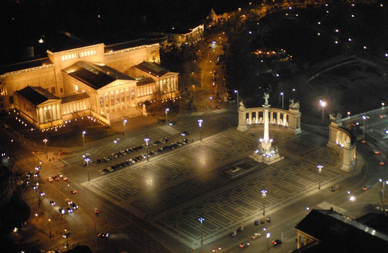
A multi view UNESCO Postcard. Budapest, including the Banks of the Danube, the Buda Castle Quarter and Andrássy Avenue
This site has the remains of monuments such as the Roman city of Aquincum and the Gothic castle of Buda, which have had a considerable influence on the architecture of various periods. It is one of the world's outstanding urban landscapes and illustrates the great periods in the history of the Hungarian capital.
Andrássy Avenue is an iconic boulevard in Budapest, Hungary, dating back to 1872. It links Elizabeth Square with City Park. Flanked by Eclectic Neo-renaissance palaces and houses featuring fine facades, staircases and interiors, it was recognised as a World Heritage Site in 2002.
Andrássy Avenue with the Hungarian State Opera House (left side), 1896.
Information and Image Obtained from World Heritage Center, Wikipedia, the free encyclopedia
Wieliczka Salt Mine
Card # 13
These postcard sent to me by Rafal Sulima
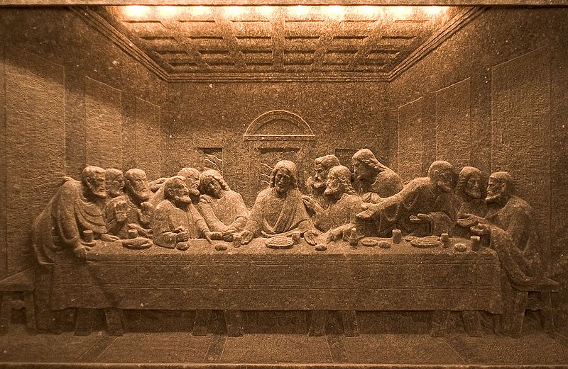
Is located southern Poland. In a town called Wieliczka. Depth of 327 meters and is over 300km long. Producing table salt since 13th century till 2007. In 1978 the Wieliczka salt mine was placed on the original UNESCO list of the World Heritage Sites. The oldest sculptures were carved out of rock salt by miners; more recent figures have been fashioned by contemporary artists. Commercial mining was discontinued in 1996 due to low salt prices and mine flooding.
Da Vinci's "The Last Supper"
carved in a wall of rock salt
Old corridor
Information and Image Obtained From Wikipedia, the free encyclopedia
Tuesday, August 18, 2009
Ancient City of Polonnaruwa
Card # 12
These postcard sent to me by Aravinda Babu
Before 1070 CE. Hampi to India and this second largest ancient of Sri Lanka Polonaruwa for Sri Lanka. The real hero of Polonaruwa was Prakramabahu I who was adamant that no drop of water falling from the heavens was to be wasted, and each be used toward the development of the land. The ancient city of Polonnaruwa has been declared a World Heritage site by UNESCO in 1982. It was once a royal capital for both Indian as well as Sinhalese kings and one can, at times, see traces of the influence of one on the other.
The South Indian Chola kings and the Sinhalese Vijayabahu I, King Parakramabahu I and King Nissankamalla were largely responsible for its architectural achievements. Polonnaruwa was a well planned city. According to historical records, King Parakramabahu the Great had built several housing complexes. The houses of the rich would have been made out of brick while the poor would have lived in houses made of wattle and daub or timber with thatched roofs.Image
Parackramabahu statue
Information and Image Obtained From Wikipedia, the free encyclopedia, Discover Sri Lanka, The Hindu
To read more and discover about Polonnaruwa go the these various interesting site's..
External links
Saturday, August 15, 2009
Museumsinsel (Museum Island), Berlin
Card # 11
These postcard sent to me by Rafal Sulima
This beautiful Museum added to UNESCO World Heritage Sites in 1999. In in the spree river in the center of the city. Constructed under several Prussian Kings, originally a residential area dedicated to "art and science" by King Frederick William IV of Prussia in 1841. is the centerpiece of Berlin’s cultural heritage.
The Old National Gallery (Alte Nationalgalerie) was completed in 1876, also according to designs by Friedrich August Stüler, to host a collection of 19th century art donated by banker Joachim H. W. Wagener. In 1904 the Kaiser-Friedrich-Museum, today called the Bode Museum, was opened. It exhibits the sculpture collections and late Antique and Byzantine art.
The final museum of the complex was constructed in 1930, it was the Pergamon Museum. The museum contains multiple reconstructed immense and historically significant buildings such as the Pergamon Altar and the Ishtar Gate of Babylon.
Information Obtained From Wikipedia, the free encyclopedia
Sacred City of Anuradhapura, Srilanka
These postcard sent to me by Ravindra
Anuradhapura, according to legend, was first settled by Anuradha, a follower of Prince Vijaya the founder of the Sinhala race. Later, it was made the Capital by King Pandu kabhaya about 380 BCE. In 1982 this Sacred City of Anuradhapura has become UNESCO World Heritage Site. Is famous for ruins of ancient Lanka civilization.Archaeological saying it is date as far back as 10th century BC but according to historical data the city was founded in the 5th century BC. The city also had some of the most complex irrigation systems of the ancient world. Most of the great reservoir tanks still survive today, and some many be the oldest surviving reservoirs in the world. Anuradhapuram was permanently abandoned and hidden in the jungle for centuries after an invasion in 993 AD. Later in the 19th centuries it discover by the British and became a Biddhist pilgrimage site.
Information Obtained From Wikipedia, the free encyclopedia, tourslanka.com, sacred-destinations.com
Anuradhapura
Image Obtained From Wikipedia, the free encyclopedia
Thursday, August 6, 2009
Mount Taishan, China
Card # 9 (My first UNESCO Postcard from Postcrossing)
These postcard sent to me by Li Zhe from Postcrossing
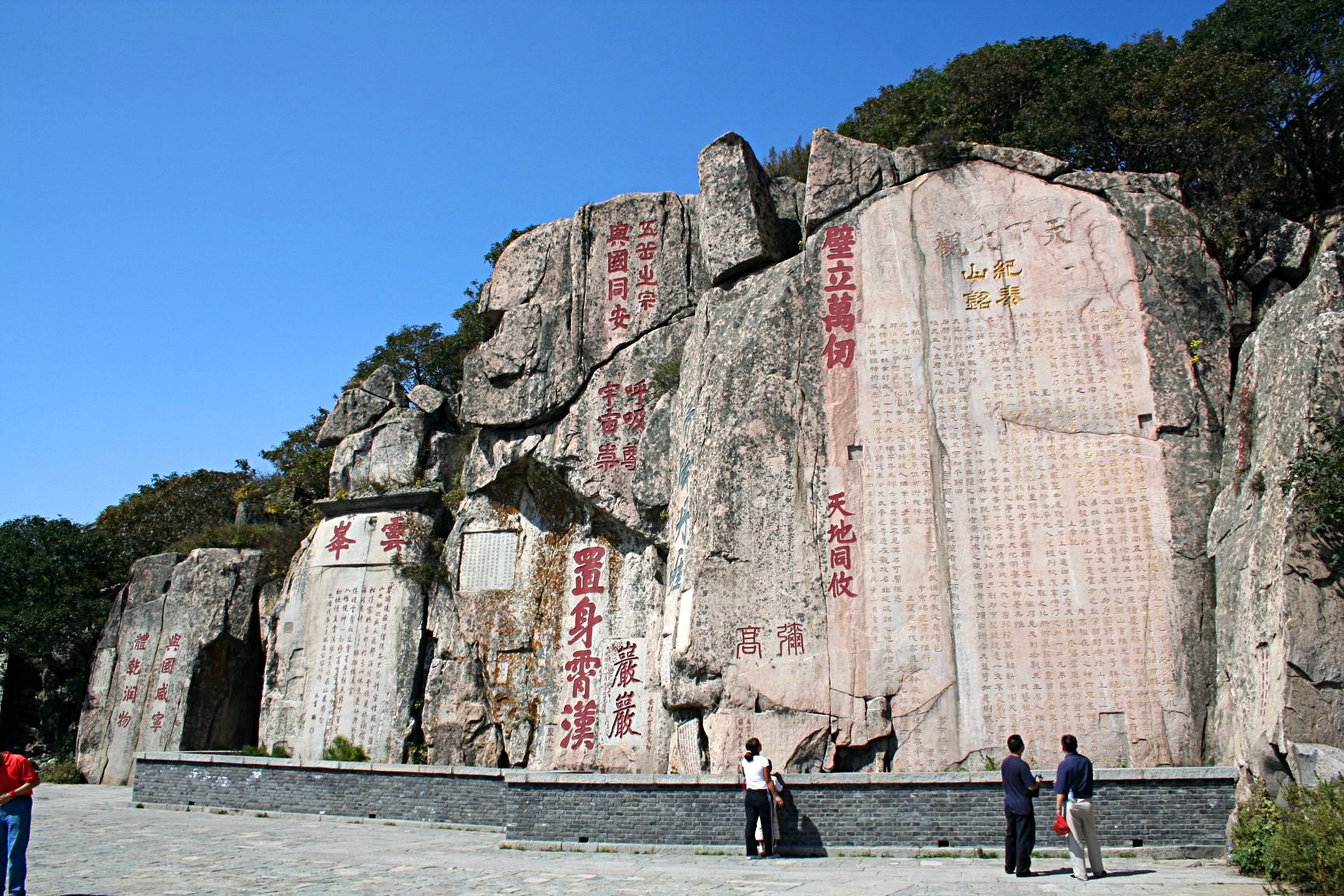
nother UNESCO World Heritage Postcard i received from a Postcrossing friend. Mount Tai entered UNESCO World Heritage Site 1987. Mount Tai resided in China Shandong Province, one of the Five Sacred Mountains with rich historical and cultural. It is associated with sunrise, birth, and renewal, and is often regarded the foremost of the five. The temples on its slopes have been a destination for pilgrims for 3,000 years. Religious worship of Mount Tai has a tradition of 3,000 years
Stone inscriptions at Mount Tai
The Temple of the God of Mount Tai, known as the Dai Temple (Dai Miao), is the largest and most complete ancient building complex in the area. It is located at the foot of Mount Tai in the city of Tai'an and covers an area of 96,000 square meters. The temple was first built during the Qin Dynasty. Since the time of the Han Dynasty (206 BC – 220 AD), its design has been a replica of the imperial palace, which makes it one out of three extant structures in China with the features of an imperial palace (the other two are the Forbidden City and the Confucius Temple in Qufu). The temple has five major halls and many small buildings. The centerpiece is the Palace of Heavenly Blessings (Tian Kuang), built in 1008, during the Northern Song Dynasty. The hall houses the mural painting "The God of Mount Tai Making a Journey", dated to the year 1009. The mural extends around the eastern, western and northern walls of the hall and is 3.3 metres high and 62 metres long. The theme of the painting is an inspection tour by the god. Next to the Palace of Heavenly Blessings stand the Yaocan Pavilion and the entrance archway as well as the Bronze Pavilion in the northeast corner. The Dai Temple is surrounded by the 2,100 year-old Han Dynasty cypresses.
Information and Image Obtained From Wikipedia, the free encyclopedia
Tuesday, August 4, 2009
Group of Monuments at Hampi
Card # 8
These postcard sent to me by my friend Mr.Kasinath.
http://shipthemegallery.blogspot.com/
The Vijayanagara ruins are listed as the Group of Monuments at Hampi as a UNESCO World Heritage Site in 1986. The stone chariot ia a miniture temple and is carved out in a single rock, wonderful man made piece of art. The epical history of Hampi says that Hampi starts and ends with Ramayana in Threta Yuga. Materialistic proofs that Hampi might have been the capital of mighty monkey kingdom, Kishkindha. This is the very place where Hanuman was born and where he met Lord Rama and also where Vali fought his brother Sugriva.
In our emperical history it says that Hampi was founded Harihara and Bukkaraya in the year of 1336 largest hindu empire of its time. Population of over half a million. The an important city for the devotees and poets. Hundres of temple were built. Name like Shri Purandhara Dasa and Tenali Rama(Garlapati Tenali Ramakrishna) can be linked to hampi. Hampi fell down to the attacks of the five Sultans of Deccan - Bidar, Bijapur, Golconda, Ahmednagar and Berar in the year 1565. The city was looted for a period of 6 months. The temples were destroyed and the markets were plundered. The golden empire had come to an end.
Hampi has various notable Hindu temples, some of which are still active places of worship. Most notable ones are: Virupaksha Temple complex: Also known as the Pampapathi temple, it is a Shiva temple situated in the Hampi Bazaar. It predates the founding of the Vijayanagar empire. The temple has a 160-foot (49 m) high tower at its entrance. Apart from Shiva, the temple complex also contains shrines of the Hindu goddesses Bhuvaneshwari and Pampa.
Image Obtained From Wikipedia, the free encyclopedia
The best site to read about Hampi: Hampi.in
These postcard sent to me by my friend Mr.Kasinath.
http://shipthemegallery.blogspot.com/
The Vijayanagara ruins are listed as the Group of Monuments at Hampi as a UNESCO World Heritage Site in 1986. The stone chariot ia a miniture temple and is carved out in a single rock, wonderful man made piece of art. The epical history of Hampi says that Hampi starts and ends with Ramayana in Threta Yuga. Materialistic proofs that Hampi might have been the capital of mighty monkey kingdom, Kishkindha. This is the very place where Hanuman was born and where he met Lord Rama and also where Vali fought his brother Sugriva.
In our emperical history it says that Hampi was founded Harihara and Bukkaraya in the year of 1336 largest hindu empire of its time. Population of over half a million. The an important city for the devotees and poets. Hundres of temple were built. Name like Shri Purandhara Dasa and Tenali Rama(Garlapati Tenali Ramakrishna) can be linked to hampi. Hampi fell down to the attacks of the five Sultans of Deccan - Bidar, Bijapur, Golconda, Ahmednagar and Berar in the year 1565. The city was looted for a period of 6 months. The temples were destroyed and the markets were plundered. The golden empire had come to an end.
Hampi has various notable Hindu temples, some of which are still active places of worship. Most notable ones are: Virupaksha Temple complex: Also known as the Pampapathi temple, it is a Shiva temple situated in the Hampi Bazaar. It predates the founding of the Vijayanagar empire. The temple has a 160-foot (49 m) high tower at its entrance. Apart from Shiva, the temple complex also contains shrines of the Hindu goddesses Bhuvaneshwari and Pampa.
Image Obtained From Wikipedia, the free encyclopedia
The best site to read about Hampi: Hampi.in
Subscribe to:
Posts (Atom)