Total Pageviews

Monday, November 14, 2011

Historic Fortified City of Carcassonne

Card No 124Many thanks to my FB friend Gabriel Alejandro Etinzon

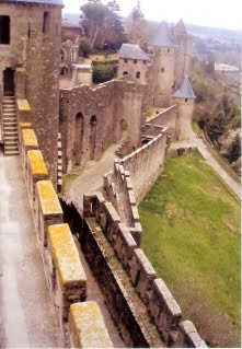
Carcassonne is a fortified French town in the Aude department, of which it is the prefecture, in the former province of Languedoc.
It is divided into the fortified Cité de Carcassonne and the more expansive lower city, the ville basse. Carcassone was founded by the Visigoths in the fifth century, though the Romans had fortified the settlement earlier. First signs of settlement in this region have been dated to about 3500 BC, but the hill site of Carsac – a Celtic place-name that has been retained at other sites in the south – became an important trading place in the 6th century BC. Read more

Monday, November 7, 2011

Iguaçu National Park

Card No 123Many thanks to my FB friend Gabriel Alejandro Etinzon

Created by federal decree nr. 1035 of January 10, 1939, the Park comprises a total area of 185,262.5 hectares and a length of about 420km, 300km of which are natural borders by bodies of water and the Brazilian and Argentinean sides together comprise around 225 thousand hectares.
On November 17, 1986, during the UNESCO conference held in Paris, the Iguaçú National Park was listed as Natural Heritage of Humanity and is one of the largest forest preservation areas in South America.
The Iguaçú National Park owes its name to the fact it includes an important area of the Iguaçú river, approximately 50km of the length of the river and the world famous Iguaçú Falls.
Read more

Information Obtained From Wikipedia, the free encyclopedia

Iguazu National Park

Card No 122Many thanks to my FB friend Gabriel Alejandro Etinzon

The semicircular waterfall at the heart of this site is some 80 m high and 2,700 m in diameter and is situated on a basaltic line spanning the border between Argentina and Brazil. Made up of many cascades producing vast sprays of water, it is one of the most spectacular waterfalls in the world. The Iguazú River ends in the Paraná River 23 km beyond the falls, after a 1320 km course. Inside the park it becomes up to 1,500 m wide and turns first south, then north, forming a large U-shape. Read More

Information Obtained from From Wikipedia, the free encyclopedia & UNESCO

LinkWithin

Related Posts with Thumbnails