Wednesday, November 24, 2010


Wednesday, November 10, 2010

Melaka and George Town, Historic Cities of the Straits of Malacca
Card no. 101
 These postcard sent to me by Lay Hoon
George Town or Georgetown, is the capital of the state of Penang in Malaysia. Named after Britain's King George III, George Town is located on the north-east corner of Penang Island and has about 220,000 inhabitants, or about 400,000 including the suburbs. Formerly a municipality and then a city in its own right, since 1976 George Town has been part of the municipality of Penang Island, though the area formerly governed by the city council is still commonly referred to as a city, and is also known as Tanjung. The inner city of George Town is a UNESCO World Heritage Site. George Town was founded in 1786 by Captain Francis Light, a trader for the British East India Company, as base for the company in the Malay States. The town was built on swampy land that had to be cleared of vegetation, levelled and filled. Read more
 Map of the City of George Town, showing the city limits in 1963
Information and Image Obtained From Wikipedia, the free encyclopedia
George Town or Georgetown, is the capital of the state of Penang in Malaysia. Named after Britain's King George III, George Town is located on the north-east corner of Penang Island and has about 220,000 inhabitants, or about 400,000 including the suburbs. Formerly a municipality and then a city in its own right, since 1976 George Town has been part of the municipality of Penang Island, though the area formerly governed by the city council is still commonly referred to as a city, and is also known as Tanjung. The inner city of George Town is a UNESCO World Heritage Site. George Town was founded in 1786 by Captain Francis Light, a trader for the British East India Company, as base for the company in the Malay States. The town was built on swampy land that had to be cleared of vegetation, levelled and filled. Read more
Information and Image Obtained From Wikipedia, the free encyclopedia

Group of Monuments at Mahabalipuram
Card no. 99
 This postcard sent to me by Kasinath.R
This group of sanctuaries, founded by the Pallava kings, was carved out of rock along the Coromandel coast in the 7th and 8th centuries. Barely 58 km from Chennai at Mahabalipuram, this world heritage site in Tamil Nadu gained UNESCO World Heritage site distinction in 1984. The temple town which was a seaport, is believed to be over two thousand years old and has approximately forty monuments including the largest open-air bas-relief in the world. The town is said to have gained prominence under the rule of Mamalla. Read more
Information Obtained From Wikipedia, the free encyclopedia
Great Living Chola Temples
Card no. 98 This postcard prepared and sent to me by Kasinath.R
http://shipthemegallery.blogspot.com/
The Great Living Chola Temples are temples built during the Chola rule in the south of India. These temples are the Brihadisvara Temple at Thanjavur, the Temple of Gangaikondacholisvaram and the Airavatesvara Temple at Darasuram. The Brihadisvara Temple was declared by UNESCO as a World Heritage Site in 1987; the Temple of Gangaikondacholisvaram and the Airavatesvara Temple at Darasuram were added as extensions to the site in 2004. The site is now known as the "Great Living Chola Temples".
Information Obtained From Wikipedia, the free encyclopedia
The Loire Valley between Sully-sur-Loire and Chalonnes
Card no. 97
 This postcard sent to me by Gabriel Alejandro Etinzon
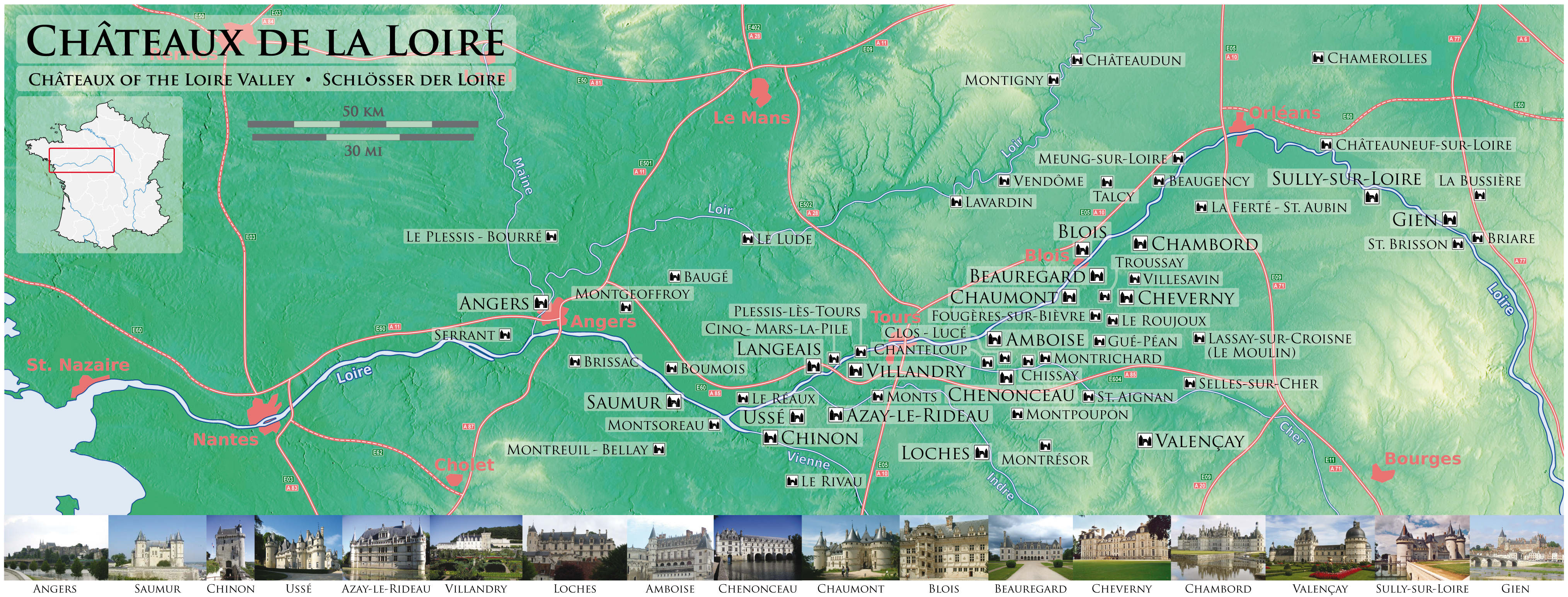
On December 2, 2000, UNESCO added the central part of the Loire River valley, between Maine and Sully-sur-Loire, to its list of World Heritage Sites. In choosing this area that includes the French départements of Loiret, Loir-et-Cher, Indre-et-Loire, and Maine-et-Loire, the committee said that the Loire Valley is: "an exceptional cultural landscape, of great beauty, comprised of historic cities and villages, great architectural monuments - the Châteaux - and lands that have been cultivated and shaped by centuries of interaction between local populations and their physical environment, in particular the Loire itself. Read more
On December 2, 2000, UNESCO added the central part of the Loire River valley, between Maine and Sully-sur-Loire, to its list of World Heritage Sites. In choosing this area that includes the French départements of Loiret, Loir-et-Cher, Indre-et-Loire, and Maine-et-Loire, the committee said that the Loire Valley is: "an exceptional cultural landscape, of great beauty, comprised of historic cities and villages, great architectural monuments - the Châteaux - and lands that have been cultivated and shaped by centuries of interaction between local populations and their physical environment, in particular the Loire itself. Read more
Historic City of Trogir
Card no. 96
 This postcard sent to me by Jelena M.
Trogir is a historic town and harbour on the Adriatic coast in Split-Dalmatia County, Croatia, with a population of 12,995 (2001)and a total municipality population of 13,322 (2001). The historic city of Trogir is situated on a small island between the Croatian mainland and the island of Čiovo. It lies 27 kilometres west of the city of Split. Since 1997, the historic centre of Trogir has been included in the UNESCO list of World Heritage Sites. In the 3rd century BC, Tragurion was founded by Greek colonists from the island of Vis, and it developed into a major port until the Roman period. From the 9th century on, Trogir paid tribute to Croatian rulers. In 1123 Trogir was conquered and almost completely demolished by the Saracens. However, Trogir recovered in a short period to experience powerful economic prosperity in the 12th and the 13th centuries. On the fall of Venice in 1797, Trogir became a part of the Habsburg Empire which ruled over the city until 1918, with the exception of French occupation from 1806 to 1814. After World War I, Trogir, together with Croatia, became a part of the State of Slovenes, Croats and Serbs and subsequently the Kingdom of Yugoslavia. During this period Italian citizens, until 1918 the ruling class and almost half part of the population, were forced to leave for Italy. During World War II, Trogir was occupied by Italy and subsequently liberated in 1944. Since then it belonged to the second Yugoslavia, and from 1991 to Croatia. Read more
Infomation and Obtained From Wikipedia, the free encyclopedia
Stari Grad Plain
Card no. 95
 This postcard sent to me by Jelena M.
The Stari Grad Plain on the island of Hvar is an agricultural landscape that was set up by the ancient Greek colonists in the 4th century BC, and remains in use today. The plain is by and large still in its original form. The ancient layout has been preserved by careful maintenance of the stone walls over 24 centuries, along with the stone shelters (known locally as trims, and the water collection system. The same crops, mainly grapes and olives, are still grown in the fields, and the site is also a natural reserve. The site is a valuable example of the ancient Greek system of agriculture.
The plain demonstrates the comprehensive system of agriculture as used by the ancient Greeks. The land was divided into geometrical parcels (chora) bounded by dry stone walls. The system included a rainwater recovery system involving the use of gutters and storage cisterns. The original field layout has been respected by the continuous maintenance of the boundary walls by succeeding generations. Agricultural activity in the chora has been uninterrupted for 24 centuries up to the present day. What we see today is a continuation of the cultural landscape of the original Greek colonists.
The Stari Grad Plain is Croatia's 7th location protected by the UNESCO.
Information Obtained From Wikipedia, the free encyclopedia
Historical Complex of Split with the Palace of Diocletian
Card no. 94
 This postcard sent to me by Jelena M.
Diocletian's Palace is a building in Split, Croatia, that was built by the Roman emperor Diocletian at the turn of the fourth century AD.
Diocletian built the massive palace in preparation for his retirement on 1 May 305 AD. It lies in a bay on the south side of a short peninsula running out from the Dalmatian coast, four miles from Salona, the capital of the Roman province of Dalmatia. The terrain slopes gently seaward and is typical karst, consisting of low limestone ridges running east to west with marl in the clefts between them.
 In November 1979 UNESCO, in line with the international convention on cultural and natural heritage, adopted a proposal that the historic city of Split built around the Palace should be included in the register of World Cultural Heritage.
In November 2006 the City Council decided to permit over twenty new buildings within the palace (including a shopping and garage complex), despite the fact that the palace had been declared a UNESCO World Heritage Monument. It is said that this decision was politically motivated and largely due to lobbying by local property developers. Once the public in 2007 came aware of the project, they petitioned against the decision and won. No new buildings, shopping center or the underground garage was built.
The World Monuments Fund has been working on a conservation project at the palace, including surveying structural integrity and cleaning and restoring the stone and plasterwork, expected to be completed in 2009. Much restoration is still needed, including excavating the extensive basement which was buried during the bombardment by the allies in World War II.
The palace is depicted on the reverse of the Croatian 500 kuna banknote, issued in 1993. Read more

Infomation and Image Obtained From Wikipedia, the free encyclopedia
Diocletian's Palace is a building in Split, Croatia, that was built by the Roman emperor Diocletian at the turn of the fourth century AD.
Diocletian built the massive palace in preparation for his retirement on 1 May 305 AD. It lies in a bay on the south side of a short peninsula running out from the Dalmatian coast, four miles from Salona, the capital of the Roman province of Dalmatia. The terrain slopes gently seaward and is typical karst, consisting of low limestone ridges running east to west with marl in the clefts between them.
In November 2006 the City Council decided to permit over twenty new buildings within the palace (including a shopping and garage complex), despite the fact that the palace had been declared a UNESCO World Heritage Monument. It is said that this decision was politically motivated and largely due to lobbying by local property developers. Once the public in 2007 came aware of the project, they petitioned against the decision and won. No new buildings, shopping center or the underground garage was built.
The World Monuments Fund has been working on a conservation project at the palace, including surveying structural integrity and cleaning and restoring the stone and plasterwork, expected to be completed in 2009. Much restoration is still needed, including excavating the extensive basement which was buried during the bombardment by the allies in World War II.
The palace is depicted on the reverse of the Croatian 500 kuna banknote, issued in 1993. Read more
Infomation and Image Obtained From Wikipedia, the free encyclopedia
Tuesday, November 9, 2010
The Old City of Jerusalem and its Walls
Card no 93
 This postcard sent to me by Ori Stamps
The Old City it lies within East Jerusalem. Until the 1860s this area constituted the entire city of Jerusalem. Traditionally, the Old City has been divided into four uneven quarters, the Muslim Quarter, the Christian Quarter, the Jewish Quarter and the Armenian Quarter. In 1980, Jordan proposed the Old City to be inscribed on the UNESCO World Heritage Site List. It was added to the List in 1981. In 1982, Jordan requested that it be added to the List of World Heritage Sites in danger. In 2010, Jerusalem's oldest fragment of writings was found outside of the Old City's walls. According to the Bible, before King David's conquest of Jerusalem in the 11th century BCE the city was home to the Jebusites.
The Muslim Quarter is the largest and most populous of the four quarters and is situated in the northeastern corner of the Old City, extending from the Lions' Gate in the east, along the northern wall of the Temple Mount in the south, to the Damascus Gate route in the west. Its population was 22,000 in 2005. Like the other three quarters of the Old City, the Muslim quarter had a mixed population of Jews as well as Muslims and Christians until the riots of 1929. Today 60 Jewish families live in the Muslim Quarter, and a few yeshivot are located there. The main one is Yeshivat Ateret Cohanim.
The Christian Quarter is situated in the northwestern corner of the Old City, extending from the New Gate in the north, along the western wall of the Old City as far as the Jaffa Gate, along the Jaffa Gate - Western Wall route in the south, bordering on the Jewish and Armenian Quarters, as far as the Damascus Gate in the east, where it borders on the Muslim Quarter. The quarter contains the Church of the Holy Sepulchre, one of Christianity's holiest places.
The Armenian Quarter is the smallest of the four quarters of the Old City. Although the Armenian people are Christians, the Armenian Quarter is distinct from the Christian Quarter. Despite the small size and population of this quarter, the Armenians and their Patriarchate remain staunchly independent and form a vigorous presence in the Old City. After the 1948 Arab-Israeli War, the four quarters of the city came under Jordanian control. Jordanian law required Armenians and other Christians to “give equal time to the Bible and Qur'an” in private Christian schools, and restricted the expansion of church assets. The 1967 war is remembered by residents of the quarter as a miracle, after two unexploded bombs were found inside the Armenian monastery. Today more than ~3,000 Armenians live in Jerusalem, 500 of them in the Armenian Quarter. Some are temporary residents studying at the seminary or working as church functionaries. The Patriarchate owns the land in this quarter as well as valuable property in West Jerusalem and elsewhere. In 1975, a theological seminary was established in the Armenian Quarter. After the 1967 war, the Israeli government gave compensation for repairing any churches or holy sites damaged in the fighting, regardless of who caused the damage.
The Jewish Quarter lies in the southeastern sector of the walled city, and stretches from the Zion Gate in the south, along the Armenian Quarter on the west, up to the Cardo in the north and extends to the Western Wall and the Temple Mount in the east. The quarter has had a rich history, with a nearly continual Jewish presence since the eighth century BCE. In 1948 its population of about 2,000 Jews was besieged, and forced to leave en masse.[14] The quarter was completely sacked by the Arabs, with ancient synagogues destroyed.
The quarter remained under Jordanian control until its capture by Israeli paratroops in the Six-Day War of 1967. A few days later, Israeli authorities ordered the demolition of the adjacent Moroccan Quarter, relocating all of its inhabitants, in order to facilitate public access to the Western Wall.
The section of the Jewish quarter destroyed prior to 1967 has since been rebuilt and settled, and has a population of 2,348 (as of 2004),[15] and many large educational institutions have taken up residence. Before being rebuilt, the quarter was carefully excavated under the supervision of Hebrew University archaeologist Nahman Avigad. The archaeological remains, on display in a series of museums and outdoor parks, to visit which tourists descend two or three stories beneath the level of the current city, collectively form one of the world's most accessible archaeological sites. The former Chief Rabbi is Rabbi Avigdor Nebenzahl, and current is his son Rabbi Chizkiyahu Nebenzahl who is on the faculty of Yeshivat Netiv Aryeh situated directly across from the Kotel. Read more
Information and Image Obtained From Wikipedia, the free encyclopedia

The Old City it lies within East Jerusalem. Until the 1860s this area constituted the entire city of Jerusalem. Traditionally, the Old City has been divided into four uneven quarters, the Muslim Quarter, the Christian Quarter, the Jewish Quarter and the Armenian Quarter. In 1980, Jordan proposed the Old City to be inscribed on the UNESCO World Heritage Site List. It was added to the List in 1981. In 1982, Jordan requested that it be added to the List of World Heritage Sites in danger. In 2010, Jerusalem's oldest fragment of writings was found outside of the Old City's walls. According to the Bible, before King David's conquest of Jerusalem in the 11th century BCE the city was home to the Jebusites.
The Muslim Quarter is the largest and most populous of the four quarters and is situated in the northeastern corner of the Old City, extending from the Lions' Gate in the east, along the northern wall of the Temple Mount in the south, to the Damascus Gate route in the west. Its population was 22,000 in 2005. Like the other three quarters of the Old City, the Muslim quarter had a mixed population of Jews as well as Muslims and Christians until the riots of 1929. Today 60 Jewish families live in the Muslim Quarter, and a few yeshivot are located there. The main one is Yeshivat Ateret Cohanim.
The Christian Quarter is situated in the northwestern corner of the Old City, extending from the New Gate in the north, along the western wall of the Old City as far as the Jaffa Gate, along the Jaffa Gate - Western Wall route in the south, bordering on the Jewish and Armenian Quarters, as far as the Damascus Gate in the east, where it borders on the Muslim Quarter. The quarter contains the Church of the Holy Sepulchre, one of Christianity's holiest places.
The Armenian Quarter is the smallest of the four quarters of the Old City. Although the Armenian people are Christians, the Armenian Quarter is distinct from the Christian Quarter. Despite the small size and population of this quarter, the Armenians and their Patriarchate remain staunchly independent and form a vigorous presence in the Old City. After the 1948 Arab-Israeli War, the four quarters of the city came under Jordanian control. Jordanian law required Armenians and other Christians to “give equal time to the Bible and Qur'an” in private Christian schools, and restricted the expansion of church assets. The 1967 war is remembered by residents of the quarter as a miracle, after two unexploded bombs were found inside the Armenian monastery. Today more than ~3,000 Armenians live in Jerusalem, 500 of them in the Armenian Quarter. Some are temporary residents studying at the seminary or working as church functionaries. The Patriarchate owns the land in this quarter as well as valuable property in West Jerusalem and elsewhere. In 1975, a theological seminary was established in the Armenian Quarter. After the 1967 war, the Israeli government gave compensation for repairing any churches or holy sites damaged in the fighting, regardless of who caused the damage.
The Jewish Quarter lies in the southeastern sector of the walled city, and stretches from the Zion Gate in the south, along the Armenian Quarter on the west, up to the Cardo in the north and extends to the Western Wall and the Temple Mount in the east. The quarter has had a rich history, with a nearly continual Jewish presence since the eighth century BCE. In 1948 its population of about 2,000 Jews was besieged, and forced to leave en masse.[14] The quarter was completely sacked by the Arabs, with ancient synagogues destroyed.
The quarter remained under Jordanian control until its capture by Israeli paratroops in the Six-Day War of 1967. A few days later, Israeli authorities ordered the demolition of the adjacent Moroccan Quarter, relocating all of its inhabitants, in order to facilitate public access to the Western Wall.
The section of the Jewish quarter destroyed prior to 1967 has since been rebuilt and settled, and has a population of 2,348 (as of 2004),[15] and many large educational institutions have taken up residence. Before being rebuilt, the quarter was carefully excavated under the supervision of Hebrew University archaeologist Nahman Avigad. The archaeological remains, on display in a series of museums and outdoor parks, to visit which tourists descend two or three stories beneath the level of the current city, collectively form one of the world's most accessible archaeological sites. The former Chief Rabbi is Rabbi Avigdor Nebenzahl, and current is his son Rabbi Chizkiyahu Nebenzahl who is on the faculty of Yeshivat Netiv Aryeh situated directly across from the Kotel. Read more
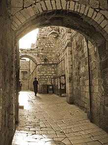
Jerusalem Old City street
Information and Image Obtained From Wikipedia, the free encyclopedia
Anjar
Card no 92
 This postcard sent to me by Daniela Rosu Abi Abboud
Anjar, also known as Haoush Mousa is a town of Lebanon located in the Bekaa Valley. The population is about 2,400. Anjar's six neighborhoods are: Haji Hababli, Kabusia, Vakif, Khodr Bek, Yoghun Oluk, Bitias. Anjar also contains a special sector containing the Anjar antiquities and ruins. The majority of Anjar's Armenians are Armenian Apostolics (Orthodox) and belong to the Armenian Apostolic Church and Holy See of Cilicia. Armenian Apostolic Saint Paul Church is the second largest Armenian church in Lebanon. Read more
Information Obtained From Wikipedia, the free encyclopedia
Baalbek
Card no 91
 This postcard sent to me by Daniela Rosu Abi Abboud
Baalbek is a town in the Bekaa Valley of Lebanon. It is famous for its exquisitely detailed yet monumentally scaled temple ruins of the Roman period, when Baalbek, then known as Heliopolis. It is Lebanon's greatest Roman treasure, largest and most noble Roman temples ever built and it can be counted among the wonders of the ancient world. The gods worshiped here, the triad of Jupiter, Venus and Bacchus, were grafted onto the indigenous deities of Hadad, Atargatis and a young male god of fertility. Local influences are also seen in the planning and layout of the temples, which vary from the classic Roman design. "Baalbek, with its colossal structures, is one of the finest examples of Imperial Roman architecture at its apogee", UNESCO reported in making Baalbek a World Heritage Site in 1984. When the Committee inscribed the site, it expressed the wish that the protected area include the entire town within the Arab walls, as well as the south-western extramural quarter between Bastan-al-Khan, the Roman site and the Mameluk mosque of Ras-al-Ain. Lebanon's representative gave assurances that the Committee's wish would be honored. Read more
Information Obtained From Wikipedia, the free encyclopedia
Subscribe to:
Posts (Atom)