Total Pageviews

Sunday, June 9, 2013

Lage Vuurtoren Van Ijmuiden, Amsterdam

Lighthouse No.4

From Post-crossing


The Lage vuurtoren van IJmuiden is a round, cast-iron lighthouse in IJmuiden, Netherlands, designed by Quirinus Harder. It was built in 1878 by D.A. Schretlen & Co, a company in Leiden and activated the following year.
In 1909, the top three sections were moved to Vlieland where they serve as a separate lighthouse.

In 1966 the lighthouse was moved slightly. Together with the Hoge vuurtoren van IJmuiden, the 24-meter high lighthouse forms a pair of leading lights marking the IJgeul (the entrance on the North Sea to the North Sea Canal). The lighthouse now has five stories and 88 steps; it is unmanned and not open for visitors. Since 1981 it is a Rijksmonument.

Information Obtained From Wikipedia, the free encyclopedia

Vesteralen lighthouse Norway, Germany

Lighthouse No. 3

From Post-crossing

Saturday, June 8, 2013

Tankar Lighthouse Kokkola, Finland

Lighthouse No.2

From Post-crossing

Tankar is a small lighthouse island which has been inhabited since the 16th century. The oldest buildings are a chapel built in 1754 and fisherman’s hut built in 1768. The lighthouse was completed in 1889.

Today Tankar is a popular tourist attraction offering visitors an experience of nature and an insight into what life used to be like in the archipelago.

Information Obtained www.spottinghistory.com/view/690/tankar/

Mollosund lighthouse, Sweden.

Lighthouse No.1
built in early 1900 at Orust (west-coast)


From Post-crossing

Ruins of Deir el-Medina. A UNESCO World Heritage Site

Card No. 163

This beautiful Postcard i received from postcrossing :)

Historic Centre of Saint Petersburg and Related Groups of Monuments

Card No. 162
This beautiful Postcard i received from postcrossing :)
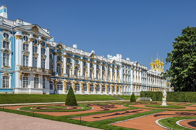
The Catherine Palace is a Rococo palace located in the town of Tsarskoye Selo (Pushkin), 25 km south-east of St. Petersburg,.The residence originated in 1717, when Catherine I of Russia engaged the German architect Johann-Friedrich Braunstein to construct a summer palace for her pleasure. In 1733, Empress Anna commissioned Mikhail Zemtsov and Andrei Kvasov to expand the Catherine Palace. "The palace was then being built, but it was the work of Penelope: what was done today, was destroyed tomorrow. Read more


Tsarskoye Selo , Catherine Palace


The Palace Chapel

Information and Image Obtained From Wikipedia, the free encyclopedia

Historic Centre of Saint Petersburg and Related Groups of Monuments

Card No. 161
This beautiful Postcard i received from postcrossing :)

Historic Centre of Saint Petersburg and Related Groups of Monuments is the name used by UNESCO when it collectively designated the historic core of the Russian city of St. Petersburg, as well as buildings and ensembles located in the immediate vicinity as a World Heritage Site in 1991.
The site was recognised for its architectural heritage, fusing Baroque, Neoclassical and traditional Russian-Byzantine influences.


Saint Petersburg is often described as the most Western city of Russia, as well as its cultural capital. It is the northernmost city in the world to have a population of over one million. The Historic Centre of Saint Petersburg and Related Groups of Monuments constitute a UNESCO World Heritage Site. Saint Petersburg is also home to The Hermitage, one of the largest art museums in the world. A large number of foreign consulates, international corporations, banks and other businesses are located in Saint Petersburg.

The Winter Palace in Saint Petersburg, Russia, was, from 1732 to 1917, the official residence of the Russian monarchs. Situated between the Palace Embankment and the Palace Square, adjacent to the site of Peter the Great's original Winter Palace, the present and fourth Winter Palace was built and altered almost continuously between the late 1730s and 1837, when it was severely damaged by fire and immediately rebuilt. The storming of the palace in 1917 as depicted in Soviet paintings and Eisenstein's 1927 film October became an iconic symbol of the Russian Revolution.
The palace was constructed on a monumental scale that was intended to reflect the might and power of Imperial Russia. From the palace, the Tsar ruled over 22,400,000 square kilometres (8,600,000 sq mi) (almost 1/6 of the Earth's landmass) and over 125 million subjects by the end of the 19th century. It was designed by many architects, most notably Bartolomeo Rastrelli, in what came to be known as the Elizabethan Baroque style. The green-and-white palace has the shape of an elongated rectangle, and its principal façade is 250 m long and 100 ft (30 m) high. The Winter Palace has been calculated to contain 1,786 doors, 1,945 windows, 1,500 rooms and 117 staircases. The rebuilding of 1837 left the exterior unchanged, but large parts of the interior were redesigned in a variety of tastes and styles, leading the palace to be described as a "19th-century palace inspired by a model in Rococo style." Read More

Information Obtained From Wikipedia, the free encyclopedia

Historic Centre of Riga, Latvia

Card No. 160

Another,Riga. Postcard i received from postcrossing :)

Friday, February 15, 2013

Turkey

12-12-2012 Special postal mark, Postcard from my friend Cuneyt Ozarikan.

Historic Centre of Avignon: Papal Palace, Episcopal Ensemble and Avignon Bridge

Card No. 159

Thanks to my FB Friend Ulla

Avignon (French pronunciation: Occitan: Avinhon in classical norm or Avignoun in Mistralian norm) is a French commune in southeastern France in the départment of the Vaucluse bordered by the left bank of the Rhône river. Of the 94,787 inhabitants of the city (as of 1 January 2010), about 12,000 live in the ancient town centre surrounded by its medieval ramparts.

Often referred to as the "City of Popes" because of the presence of popes and antipopes from 1309 to 1423 during the Catholic schism, it is currently the largest city and capital of the département of Vaucluse. This is one of the few French cities to have preserved its ramparts, its historic centre, the palace of the popes, Rocher des Doms, and the bridge of Avignon. It was classified a World Heritage Site by UNESCO under the criteria I, II and IV. The site of Avignon was settled very early on; the rocky outcrop (le Rocher les Doms) at the north end of the town, overlooking the Rhône River, may have been the site of a Celtic oppidum or hill fort.

Avignon, written as Avennio or Avenio in the ancient texts and inscriptions, takes its name from the Avennius clan. Founded by the Gallic tribe of the Cavares or Cavari, it became the centre of an important Phocaean colony from Massilia (present Marseilles).

Under the Romans, Avenio was a flourishing city of Gallia Narbonensis, the first Transalpine province of the Roman Empire, but very little from this period remains (a few fragments of the forum near Rue Molière).

During the inroads of the Goths, it was badly damaged in the fifth century and belonged in turn to the Goths, the kingdoms of Burgundy and of Arles, in the 12th century. It fell into the hands of the Saracens and was destroyed in 737 by the Franks under Charles Martel for having sided with the Arabs against him. Boso having been proclaimed Burgundian King of Provence, or of Arelat (after its capital Arles), by the Synod of Mantaille, at the death of Louis the Stammerer (879), Avignon ceased to belong to the Frankish kings. Read more

Information and Image Obtained From Wikipedia, the free encyclopedia

Friday, February 8, 2013

Prambanan Temple Compounds

Card No. 158

Candi Prambanan or Candi Rara Jonggrang is a 9th-century Hindu temple compound in Central Java, Indonesia, dedicated to the Trimurti, the expression of God as the Creator (Brahma), the Preserver (Vishnu) and the Destroyer (Shiva). The temple compound is located approximately 18 kilometres (11 mi) east of the city of Yogyakarta on the boundary between Central Java and Yogyakarta provinces. The temple, a UNESCO World Heritage Site, is the largest Hindu temple in Indonesia, and is one of the largest Hindu temples in Southeast Asia. It is characterized by its tall and pointed architecture, typical of Hindu temple architecture, and by the towering 47-metre-high (154 ft) central building inside a large complex of individual temples. One of the most majestic temples in Southeast Asia, Prambanan attracts many visitors from across the world.

Prambanan is the largest Hindu temple of ancient Java, and the construction of this royal temple was probably started by Rakai Pikatan as the Hindu Sanjaya Dynasty's answer to the Buddhist Sailendra Dynasty's Borobudur and Sewu temples nearby. Historians suggest that the construction of Prambanan probably was meant to mark the return of the Hindu Sanjaya Dynasty to power in Central Java after almost a century of Buddhist Sailendra Dynasty domination. Nevertheless, the construction of this massive Hindu temple signifies that the Medang court had shifted the focus of its patronage from Mahayana Buddhism to Shivaist Hinduism.

A temple was first built at the site around 850 CE by Rakai Pikatan and expanded extensively by King Lokapala and Balitung Maha Sambu the Sanjaya king of the Mataram Kingdom. According to the Shivagrha inscription of 856 CE, the temple was built to honor Lord Shiva and its original name was Shiva-grha (the House of Shiva) or Shiva-laya (the Realm of Shiva). According to Shivagrha inscription, a public water project to change the course of a river near Shivagrha Temple was conducted during the construction of the temple. The river, identified as the Opak River, now runs north to south on the western side of the Prambanan temple compound. Historians suggest that originally the river was curved further to east and was deemed too near to the main temple. The project was done by cutting the river along a north to south axis along the outer wall of the Shivagrha Temple compound. The former river course was filled in and made level to create a wider space for the temple expansion, the space for rows of pervara (complementary) temples. Read more


The ruins of Prambanan soon after their rediscovery.


The statue of Durga Mahisasuramardini in northern cella of Shiva temple.
Information and Image Obtained From Wikipedia, the free encyclopedia

London 2012 Postcard

Thanks to my FB friend Santanu Saha

Saturday, September 29, 2012

2012 Summer Olympics-London 2012

Games of the XXX Olympiad

The 2012 Summer Olympics, officially the Games of the XXX Olympiad, and also more generally known as London 2012, was a major international multi-sport event, celebrated in the tradition of the Olympic Games, as governed by the International Olympic Committee (IOC), that took place in London, United Kingdom, from 27 July to 12 August 2012. The first event, the group stages in women's football, began two days earlier, on 25 July. More than 10,000 athletes from 204 National Olympic Committees (NOCs) participated.

Following a bid headed by former Olympic champion Sebastian Coe and then-Mayor of London Ken Livingstone, London was selected as the host city on 6 July 2005 during the 117th IOC Session in Singapore, defeating bids from Moscow, New York City, Madrid and Paris. London was the first city to officially host the modern Olympic Games three times, having previously done so in 1908 and in 1948.

A London 2012 Olympics banner at the Monument in London

Construction in preparation for the Games involved considerable redevelopment, particularly themed towards sustainability. The main focus was a new 200-hectare (490-acre) Olympic Park, constructed on a former industrial site at Stratford, East London. The Games also made use of venues which were already in place before the bid.

Olympic rings marked on a street, indicating that the lane was reserved for the use of Olympic athletes and staff.

The Games received widespread acclaim for their organisation, with the volunteers, the British military, and public enthusiasm praised particularly highly. The opening ceremony, directed by Danny Boyle, also received near-universal acclaim. During the Games, Michael Phelps became the most decorated Olympic athlete of all time, winning his 22nd medal. Great Britain achieved its highest tally of gold medals since 1908, finishing third in the medal table. Saudi Arabia, Qatar and Brunei entered female athletes for the first time, meaning every currently eligible country has sent a female competitor to at least one Olympic Games. With women's boxing included, the Games became the first at which every sport had female competitors.
Read more

Information and Image Obtained From Wikipedia, the free encyclopedia

Hospicio Cabañas, Guadalajara

Card No. 157
Card from Irma Draz Facebook Friend

The Hospicio Cabañas in Guadalajara, Jalisco, Mexico, a World Heritage Site, is one of the oldest and largest hospital complexes in the Americas.

The complex was founded in 1791 by the Bishop of Guadalajara in order to combine the functions of a workhouse, hospital, orphanage, and almshouse. It owes its name to Juan Ruiz de Cabañas who was appointed to the see of Guadalajara in 1796 and engaged Manuel Tolsá, a renowned architect from Mexico City, to design the structure.

Tolsá's design was based on classic examples such as Les Invalides in Paris and El Escorial near Madrid. The buildings form a rectangle measuring 164 m by 145 m. These are single-storey structures which are 7.5 m in height. The chapel is twice as high and has a dome rising to 32.5 m. The complex is erected on one level, "so as to facilitate the movement of the sick, the aged, and children. Following the death of Cabañas in 1823, construction continued until 1829. Although it served for a time as a barracks in the mid-19th century, the hospital lasted well into the 20th century and continued to function until 1980, when the Cabañas Cultural Institute, with affiliated schools for arts and crafts, moved in. The highlight of the interior decoration is a series of monumental frescoes by José Clemente Orozco, including one of his most famed creations, the allegory of The Man of Fire (1936–39).

Information Obtained From Wikipedia, the free encyclopedia

Heritage of Mercury. Almadén and Idrija

Card No. 156

Heritage of Mercury. Almadén and Idrija is a joint UNESCO’s World Heritage site in Almadén, Spain, and Idrija, Slovenia.

The property encompasses two mercury mining sites. In Almadén mercury has been extracted since Antiquity, while in Idrija it was first found in 1490 A.D. The Almadén site includes buildings relating to its mining history, including Retamar Castle, religious buildings and traditional dwellings. The site in Idrija notably features mercury stores and infrastructure, as well as miners’ living quarters, and a miners’ theatre. The sites bear testimony to the intercontinental trade in mercury which generated important exchanges between Europe and America over the centuries. The two sites represent the two largest mercury mines in the world and were operational until recent times.

Information Obtained From Wikipedia, the free encyclopedia

Thursday, September 20, 2012

Agave Landscape and Ancient Industrial Facilities of Tequila

Card No 155
Card from Irma Draz Facebook Friend

The domestication of wild agave seems to have begun around 3,500 years ago. The wild plant may have originated in the Rio Grande canyon. The agave plant is ideally suited to the poor soil and rough terrain of the Tequila area.

Agave was extensively cultivated by the Teuchitlans and served to provide many basis necessities: its fibres were used for fabric, rope and paper, the flower stem provided wood for construction, the fleshy leaves were used as roof tiles and fuel, the spines for needles and arrow heads, the sap produced a type of honey and its juices were used for medicinal balm and fermented to produce an alcoholic drink. The leaders of the complex, stratified, Teuchitlan society created wealth from their apparent monopoly of the agave resources.

To transform the starches in the plant to sugar, for eating and fermenting into alcohol, the pineapples need cooking. There is archaeological evidence from nearby Lake Sayula (outside the nominated area) that the practice of cooking agave pineapples in open, conical ovens, made of volcanic stone, existed around 400 BC. These ovens were preheated with wood and the pineapples covered with branches and clay.

The Spanish priest, Friar Francisco Ximenez, wrote in 1615 how juice from the cooked plant was fermented to make wine flavoured with orange and melon rinds.

In the 16th century the area was conquered by the Spanish who established the town of Santiago de Tequila. The Caxcanes who were living in the areas gradually assimilated with the Spanish. In order to mitigate shortages of spirits from Europe, the Spanish experimented with local beverages and begun to distil the agave fermented juice to make vino de mezcal. At the same time rum was being developed in the Antilles and so the necessary equipment for the new agave spirit was introduced from the rum making areas.

The taxes levied on the new spirit produced a significant income for the Spanish government of Guadalajara. It funded a water supply and the government palace of Jalisco in Guadalajara. Read more

Information Obtained from unesco.org

Luther Memorials in Eisleben and Wittenberg

Card No 154

Card from Katrin Fraenkler Facebook Friend

Eisleben is a town in Saxony-Anhalt, Germany. It is famous as the hometown of Martin Luther, hence its official name is Lutherstadt Eisleben. As of 2005, Eisleben had a population of 24,552. It lies on the Halle–Kassel railway.

Eisleben is divided into old and new towns (Altstadt and Neustadt); the latter of which was created for Eisleben's miners in the 14th century.
Eisleben was first mentioned in 997 as a market called Islebia and in 1180 as a town. It belonged to the counts of Mansfeld until it passed to the Electorate of Saxony in 1780. It was assigned to the Kingdom of Prussia in 1815 and was administered within the Prussian Province of Saxony. It became part of the new state of Saxony-Anhalt after World War II. Read More

Information Obtained From Wikipedia, the free encyclopedia

Saturday, July 28, 2012

Sun Temple, Konark

Card No. 153
Entrance to bhoga-mandapa

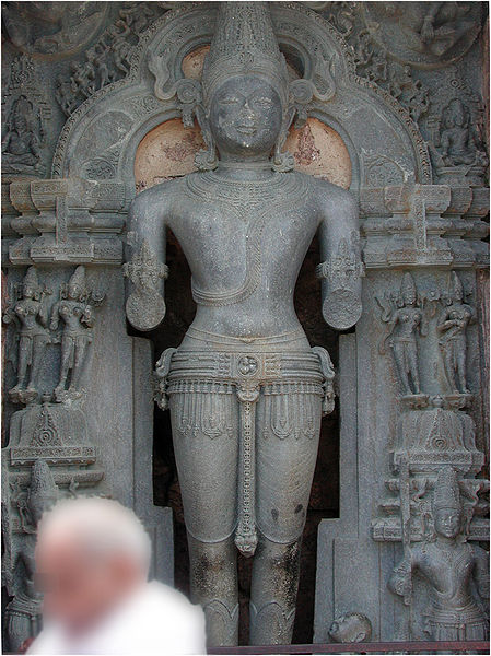
Konark Sun Temple is a 13th century Sun Temple (also known as the Black Pagoda), at Konark, in Orissa. It was constructed from oxidized and weathered ferruginous sandstone by King Narasimhadeva I (1238-1250 CE) of the Eastern Ganga Dynasty. Legend has it that the temple was constructed by Samba, the son of Lord Krishna. It is said that Samba was afflicted by leprosy, brought about by his father’s curse on him. After 12 years of penance, he was cured by Surya, the Sun God, in whose honour he built the magnificent Konark Sun Temple. The name Konark is derived from the Sanskrit word Kona (meaning angle) and word Arka (meaning sun) in reference to the temple which was dedicated to the Sun god Surya.

A sculpture of Surya - the Sun God at Konark

Located on the shoreline, now a little over 3 km from the sea, the temple takes the form of the chariot of Surya (Arka), the Sun God, and is heavily decorated with stone carving. The entire complex was designed in the form of the God's huge chariot drawn by seven spirited horses on twelve pairs of exquisitely decorated wheels at its base. The huge wheels carved at the base of the temple are one of the major attractions. The spokes of the wheels serve as sundials and the shadows cast by these can give the precise time of the day. The pyramidal roof soars over 30 m (98 ft) in height. The temple complex also contains erotic sculptures similar to the temple in Khajuraho. Read more
Information and Image Obtained From Wikipedia, the free encyclopedia

Churches and Convents of Goa

Card No. 152
Relic casket of St Francis Xavir, Old Goa (Velha Goa)

The remains of the city are a UNESCO World Heritage Site

Old Goa or Velha Goa (Velha means "old" in Portuguese) is a historical city in North Goa district in the Indian state of Goa. The city was constructed by the Bijapur Sultanate in the 15th century, and served as capital of Portuguese India from the 16th century until its abandonment in the 18th century due to a plague. It is said to have once been a city of nearly 200,000 where from, before the plague, the Portuguese traded across continents. The remains of the city are a UNESCO World Heritage Site. Old Goa is barely 10 kilometers from the state capital of Panaji.

The city was founded in the 15th century as a port on the banks of the Mandovi river by the rulers of the Bijapur Sultanate. The city was built to replace Govapuri, which lay a few kilometres to the south and had been used as a port by the Kadamba and Vijayanagar kings. Old Goa was the second capital of Bijapur under the rule of Adil Shah. It was surrounded by a moat and contained the Shah's palace, and his mosques and temples. The city was captured by the Portuguese, and was under Portuguese rule from 1510 as the administrative seat of Portuguese India. The Viceroy's residence was transferred in 1759 to the future capital, Panaji (then Pangim), at the time a village about 9 kilometres to its west.

During the mid-16th century, the Portuguese colony of Goa, especially Velha Goa, was the center of Christianisation in the East. The city was evangelised by all religious orders, since all of them had their headquarters there.[3] The population was roughly 200,000 by 1543. Malaria and cholera epidemics ravaged the city in the 17th century and it was largely abandoned, only having a remaining population of 1,500 in 1775. It was then that the viceroy moved to Pangim. It continued to be the de jure capital of Gôa until 1843, when the capital was then shifted to Pangim (Ponnjê in Konkani, Nova Goa in Portuguese and Panjim in English). The abandoned city came to be known as "Velha Goa" (in Portuguese, 'Old Goa'), to distinguish it from the new capital Nova Goa (Panjim) and probably also Goa Velha (also meaning "Old Goa"), which was the Portuguese name for the town located on the old site of Govapuri.

Velha Goa was incorporated into the Republic of India in 1961, together with the rest of Goa. Read more

Informatiom was Obtained From Wikipedia, the free encyclopedia
Wednesday, July 18, 2012

Ajanta Caves

Card No. 151
Buddha Mother & Child Ajanta Cave No.1

Since 1983, the Ajanta Caves have been a UNESCO World Heritage Site. The caves are located in the Indian state of Maharashtra, near Jalgaon, just outside the village of Ajinṭhā (20°31′56″N 75°44′44″E). Caves are only about 59 kilometers from Jalgaon Railway station (on Delhi - Mumbai, Rail line of the Central railways, India); and 104 kilometers from Aurangabad (from Ellora Caves 100 Kilometers). Ajanta Caves 30 rock-cut cave monuments which date from the 2nd century BCE to the 600 CE. The caves include paintings and sculptures considered to be masterpieces of Buddhist religious art (which depict the Jataka tales) as well as frescos which are reminiscent of the Sigiriya paintings in Sri Lanka. The caves were built in two phases starting around 2nd century BCE, with the second group of caves built around 600 CE. It is a protected monument under the Archaeological Survey of India. Read more

Information and Image Obtained From Wikipedia, the free encyclopedia

LinkWithin

Related Posts with Thumbnails