Total Pageviews

Thursday, April 22, 2010

Old Town of Lijiang

Card # 77
The town has a history going back more than 800 years and was once a confluence for trade along the old tea horse road. The Lijiang old town is famous for its orderly system of waterways and bridges. The old town of Lijiang differs from other ancient Chinese cities in architecture, history and the culture of its traditional residents the Nakhi people, therefore people there are called 胖金哥 and 胖金妹 (male and female respectively).

Lijiang old town (including Dayan, Baisha and Shuhe) was registered on the UNESCO World Heritage List in December 4, 1997. Since then, the local government has taken more responsibility for the development and protection of the old city. Lijiang's tourism also boomed, and travellers from around the world flooded in; although many locals fear that due to much of the development, the old town of Lijiang will lose its appeal. Read more
Information Obtained From Wikipedia, the free encyclopedia

Wednesday, April 21, 2010

Historic Centre of Naples

Card # 76
Another UNESCO postcard from postcrossing

Naples is a city in Italy; it is the capital of the region of Campania and of the province of Naples. The city is known for its rich history, art, culture, architecture, music and gastronomy, playing an important role in the country's history and beyond throughout much of its existence, which began more than 2,800 years ago. Naples is located halfway between two volcanic areas, the volcano Mount Vesuvius and the Phlegraean Fields, sitting on the coast by the Gulf of Naples.

A collage of Naples: in the top left is the interior of Naples Cathedral, followed by the Castello Nuovo, a view of the city harbour and the Teatro San Carlo.


Founded in the 8th century BC, as a Greek colony, under the name of Parthenope, and later Neápolis (New City), Naples is one of the oldest cities in the world, and it held an important role in Magna Graecia; while when the city became part of the Roman Republic in the central province of the Empire, was a major cultural center (Virgil is one of the symbol of the political and cultural freedom of Naples). The city has seen a multitude of civilizations come and go, each leaving their mark: now the historic city centre is listed by UNESCO as a World Heritage Site. The historic city centre of Naples is the largest in Europe (1.700 hectares). Read more

Information and Image Obtained From Wikipedia, the free encyclopedia


Tuesday, April 20, 2010

Meteora

Card # 75
Another UNESCO postcard from postcrossing

The Metéora (Greek: Μετέωρα, "suspended rocks", "suspended in the air" or "in the heavens above") is one of the largest and most important complexes of Eastern Orthodox monasteries in Greece, second only to Mount Athos. The six monasteries are built on natural sandstone rock pillars, at the northwestern edge of the Plain of Thessaly near the Pineios river and Pindus Mountains, in central Greece. The nearest town is Kalambaka. The Metéora is included on the UNESCO World Heritage List under criteria I, II, IV, V and VII. All of these monasteries are located at Metéora in Greece, and most are perched on high cliffs and accessible by staircases cut into the rock formations. They were created to serve monks and nuns following the teachings of the Greek Orthodox Church. Much of the architecture of these buildings is Athonite in origin. Of the 6 intact monasteries, only the Holy Monastery of St. Stephen is inhabited by nuns.

The Holy Monastery of Great Meteoron - This is the largest of the monasteries located at Metéora. It was erected in the mid-14th century AD and was the subject of restoration and embellishment projects in 1483 and 1552. The building serves as the main museum for tourists. The Katholikon (main church), consecrated in honour of the Transfiguration of Jesus was erected in the middle of 14th c. and 1387/88 and decorated in 1483 and 1552


In the 9th century, an ascetic group of hermit monks moved up to the ancient pinnacles.

They were the first people to inhabit Metéora. They lived in hollows and fissures in the rock towers, some of which reach 1800 ft (550m) above the plain. This great height, combined with the sheerness of the cliff walls, kept away all but the most determined visitors. Initially the hermits led a life of solitude, meeting only on Sundays and special days to worship and pray in a chapel built at the foot of a rock known as Dhoupiani. As early as the 11th century AD hermit monks were believed to be living among the caves and cutouts in the rocks. Read more

Information and Image Obtained From Wikipedia, the free encyclopedia

Kremlin and Red Square, Moscow

Card # 74
Another UNESCO postcard from postcrossing

The name The Kremlin is often used as a metonym to refer to the government of the Soviet Union (1922–1991) and its highest members (such as general secretaries, premiers, presidents, ministers, and commissars), in the same way the name Whitehall refers to the British government, or White House refers to the executive branch of the government of the United States. It is still used in reference to the government of the Russian Federation. "Kremlinology" referred to the study of Soviet policies.

Red Square (Russian: Кра́сная пло́щадь, Krásnaya plóshchad’) is a city square in Moscow. The square separates the Kremlin, the former royal citadel and currently the official residence of the President of Russia, from a historic merchant quarter known as Kitai-gorod. As major streets of Moscow radiate from here in all directions, being promoted to major highways outside the city, Red Square is often considered the central square of Moscow and all of Russia.
Read more refer to Wikipedia, the free encyclopedia

Tubbataha Reefs Natural Park

Card # 73
This postcard sent to me by Bradpete

Tubbataha Reef is an atoll coral reef located in the Sulu Sea of the Philippines. It is a marine sanctuary protected as Tubbataha Reef National Marine Park. It is nominated at the New 7 Wonders of Nature. Read more

Puerto-Princesa Subterranean River National Park

Card # 72
This postcard sent to me by Bradpete

The Puerto Princesa Subterranean River National Park is located about 50 kilometers north of the city of Puerto Princesa, Palawan, Philippines. The National Park is located in the Saint Paul Mountain Range on the northern coast of the island. It is bordered by St. Paul Bay to the north and the Babuyan River to the east. The City Government of Puerto Princesa has managed the National Park since 1992. It is also known as St. Paul's Subterranean River National Park, or St. Paul Underground River. The entrance to the Subterranean River is a short hike from the town of Sabang. Puerto Princesa Subterranean River National Park is one of the 28 finalist for the "New Seven Wonders of Nature" competition. The area also represents a habitat for biodiversity conservation. The site contains a full mountain-to-the-sea ecosystem and has some of the most important forests in Asia. It was inscribed by UNESCO as a World Heritage Site on December 4, 1999. Read more

Information Obtained From Wikipedia, the free encyclopedia

Rice Terraces of the Philippine Cordilleras

Card # 71
This postcard sent to me by Bradpete

The Banaue Rice Terraces (Tagalog: Hagdan-hagdang Palayan ng Banawe) are 2000-year old terraces that were carved into the mountains of Ifugao in the Philippines by ancestors of the indigenous people. The Rice Terraces are commonly referred to by Filipinos as the "Eighth Wonder of the World". It is commonly thought that the terraces were built with minimal equipment, largely by hand. The terraces are located approximately 1500 meters (5000 ft) above sea level and cover 10,360 square kilometers (about 4000 square miles) of mountainside. They are fed by an ancient irrigation system from the rainforests above the terraces. It is said that if the steps are put end to end it would encircle half the globe.

The Banaue terraces are part of the Rice Terraces of the Philippine Cordilleras, ancient sprawling man-made structures from 2,000 to 6,000 years old. They are found in the provinces of Kalinga, Apayao, Benguet, Mountain Province and Ifugao, and are a UNESCO World Heritage Site. Read more

The back of a Philippine 1000 Peso bill which depicts the Banaue Rice Terraces and Ifugao culture

Information and Image Obtained from From Wikipedia, the free encyclopedia

Wednesday, March 17, 2010

Discover UNESCO World Heritage with Street View

Ephesus - Selcuk - Izmir

Card # 1
Ephesus was an ancient Greek city on the west coast of Anatolia, near present-day Selçuk, Izmir Province, Turkey. It was one of the twelve cities of the Ionian League during the Classical Greek era. In the Roman period, it was for many years the second largest city of the Roman Empire; ranking behind Rome, the empire's capital. Ephesus had a population of more than 250,000 in the 1st century BC, which also made it the second largest city in the world.

The city was famed for the Temple of Artemis (completed around 550 BCE), one of the Seven Wonders of the Ancient World. The temple was destroyed in 401 CE by a mob led by St. John Chrysostom. Emperor Constantine I rebuilt much of the city and erected new public baths. The town was again partially destroyed by an earthquake in 614. The city's importance as a commercial center declined as the harbor was slowly silted up by the Cayster River.

Ephesus was one of the seven churches of Asia that are cited in the Book of Revelation. The Gospel of John may have been written here. It is also the site of a large gladiators' graveyard.

Today's archaeological site lies 3 kilometers southwest of the town of Selçuk, in the Selçuk district of İzmir Province, Turkey. The ruins of Ephesus are a favorite international and local tourist attraction, partly owing to their easy access from Adnan Menderes Airport and via the port of Kuşadası.

Information Obtained From Wikipedia, the free encyclopedia


Verla Groundwood and Board Mill

Card # 70 This postcard sent to me by Milka (Postcrossing)

Verla at Jaala, Kouvola, Finland, is a well preserved 19th century mill village and a UNESCO World Heritage Site since 1996. The first groundwood mill at Verla was founded in 1872 by Hugo Nauman but was destroyed by fire in 1876. A larger groundwood and board mill, founded in 1882 by Gottlieb Kreidl and Louis Haenel, continued to operate until 1964.

The historical paper mill turned museum of board mill technology. The historical machines were preserved in their places (except for several pieces brought from other buildings), so a guided tour to the mill follows the technological process from timber cutting and pulp production to board drying, sorting, and packing.

Information Obtained From Wikipedia, the free encyclopedia

Baroque Churches of the Philippines, Paoay Church

Card # 69 This postcard send to me by Bradpete

Paoay Church
Paoay Church (also known as the St. Augustine Church in Paoay) is a historical church located in Paoay, Ilocos Norte. During the Philippine Revolution in 1898, its coral stone bell tower was used by the Katipuneros as an observation post. Paoay Church is part of the UNESCO World Heritage List. It currently is a property of the Diocese of Laoag, Ilocos Norte.

Construction of Paoay Church was started by the Augustinian friars in 1694. It was completed in 1894 led by Fr. Antonio Estavillo and was re-dedicated in 1894.

Information Obtained from WikiPilipinas: The Hip 'n Free Philippine Encyclopedia

Baroque Churches of the Philippines, Miagao Church

Card # 68 This postcard send to me by Bradpete

Miag-ao Church
The Miag-ao Church was built in 1786 by Spanish Augustinian missionaries and was declared as part of the UNESCO World Heritage Site "Baroque Churches of the Philippines" in 1993. On the front facade, which is flanked by two watchtower belfries, one can see the unique blending of Spanish and native influences.

Fortress of Suomenlinna

Card # 67 This postcard sent by Auli (postcrossing)

Friday, March 12, 2010

Buddhist Monuments at Sanchi

Card # 66 This postcard sent to me by Sita Seshadri

Sanchi is a small village in Raisen District of the state of Madhya Pradesh, India, it is located 46 km north east of Bhopal, and 10 km from Besnagar and Vidisha in the central part of the state of Madhya Pradesh. It is the location of several Buddhist monuments dating from the third century BCE to the twelfth century CE and is one of the important places of Buddhist pilgrimage. It is a nagar panchayat in Raisen district in the Indian state of Madhya Pradesh. Toranas surround the Stupa and they each represent love, peace, trust, and courage. Today, around fifty monuments remain on the hill of Sanchi, including three stupas and several temples. The monuments have been listed among the UNESCO World Heritage Sites since 1989.

The 'Great Stupa' at Sanchi was originally commissioned by the emperor Ashoka the Great in the third century BCE. Its nucleus was a simple hemispherical brick structure built over the relics of the Buddha. It was crowned by the chatra, a parasol-like structure symbolising high rank, which was intended to honour and shelter the relics. Read more Information Obtained From Wikipedia, the free encyclopedia

The Red Fort Complex

Card # 65 This postcard sent to me by Sita Seshadri

The Red Fort is a 17th century fort complex constructed by the Mughal emperor Shahjahan in the walled city of Old Delhi (in present day Delhi, India). It served as the capital of the Mughals until 1857, when Mughal emperor Bahadur Shah Zafar was exiled by the British Indian government. The British used it as a military camp until India was made independent in 1947. It is now a popular tourist site, as well as a powerful symbol of India's sovereignty: the Prime Minister of India raises the flag of India on the rampants of the Lahori Gate of the fort complex every year on Independence Day. It was designated a UNESCO World Heritage Site in 2007. Read more Information Obtained From Wikipedia, the free encyclopedia

Mahabodhi Temple Complex at Bodh Gaya

Card # 64 This postcard sent to me by Sita Seshadri

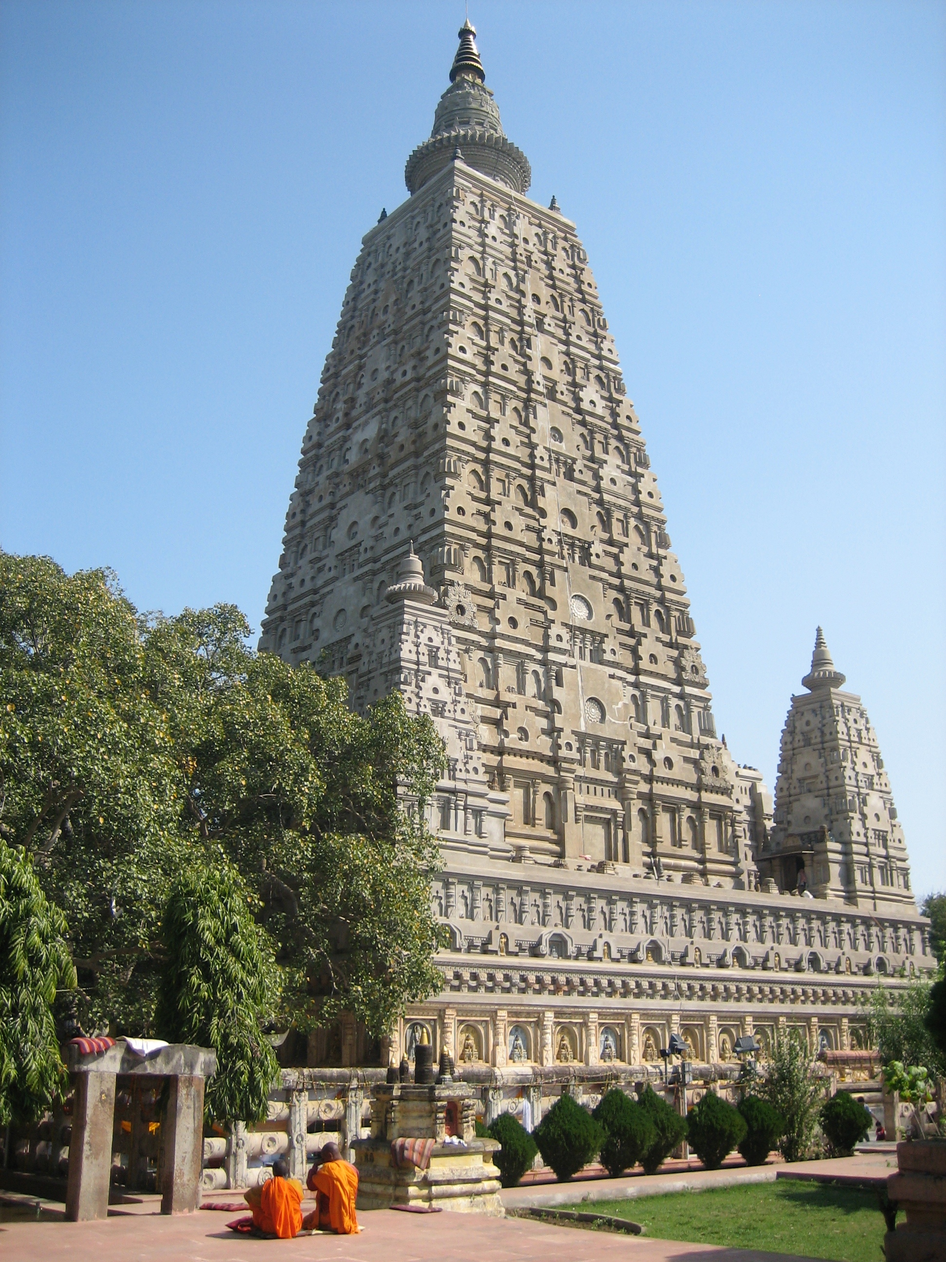
The Mahabodhi Temple (Literally: "Great Awakening Temple") is a Buddhist temple in Bodh Gaya, the location where Siddhartha Gautama, the Buddha, attained enlightenment. Bodh Gaya is located about 96 km (60 mi) from Patna, Bihar state, India. Next to the temple, to its western side, is the holy Bodhi tree. In the Pali Canon, the site is called Bodhimanda, and the monastery there the Bodhimanda Vihara. The tallest tower is 55 metres (180 ft) tall.


The temple as it appeared in the 1780s

In June 2002, the Mahabodhi Temple became a UNESCO World Heritage Site, specifically nominated for the international World heritage program.[9] All finds of religious artifacts in the area are legally protected under the Treasure Trove Act of 1878. The temple's head monk, as of September as of 2004[update], was Bhikkhu Bodhipala. Bodhipala resigned in 2007. Kalicharan Singh Yadav served as secretary until 2007. As of 2008, district magistrate Jitendra Srivastava was the Committee's chairman . According to the Temple Management Committee's website, the current[update] chief priest is Bhikkhu Chalinda.

Following the expiration of the Committee's term in September 2007, the government of Bihar delayed the appointment of a new Committee. The district magistrate has served as administrator for the temple pending the appointment of a new Committee. Eventually, on May 16, 2008 the government announced the appointment of a new Temple Management Committee. Read more

Information and Image Obtained From Wikipedia, the free encyclopedia

Thursday, March 11, 2010

Chhatrapati Shivaji Terminus (formerly Victoria Terminus)

Card # 63 This postcard sent to me by Sita Seshadri

Chhatrapati Shivaji Terminus formerly Victoria Terminus, and better known by its abbreviation CST or Bombay VT, is an historic railway station in Mumbai which serves as the headquarters of the Central Railways. It is one of the busiest railway stations in India, and serves Central Railway trains terminating in Mumbai as well as the Mumbai suburban railway. The station was designed by Frederick William Stevens, a consulting architect in 1887-1888. He received as payment 16.14 lakh rupees. Stevens earned the commission to construct the station after a masterpiece watercolour sketch by draughtsman Axel Haig. The final design bears some resemblance to St Pancras station in London.

It took ten years to complete[3] and was named "Victoria Terminus" in honour of the Queen and Empress Victoria; it was opened on the date of her Golden Jubilee in 1887. This famous architectural landmark in Gothic style was built as the headquarters of the Great Indian Peninsular Railway. Since then the station came to be known as Bombay VT.

In 1996, in response to demands by the Shiv Sena and in keeping with the policy of renaming locations with Indian names, the station was renamed by the state government after Chatrapati Shivaji, a famed 17th century Maratha king. On 2 July 2004 the station was nominated as a World Heritage Site by the World Heritage Committee of UNESCO.

In 2008, the station was featured prominently in the Academy Award winning film Slumdog Millionaire.

Victoria Terminus, 1903

On 26 November 2008, two terrorists entered the passenger hall of the CST, opened fire and threw grenades at people. The terrorists were armed with AK-47 rifles. More than 50 people were killed in the attack.

Information and Image Obtained From Wikipedia, the free encyclopedia

Ajanta Caves

Card # 62 This postcard sent to me by Sita Seshadri

Ajanta Caves in Maharashtra, India are rock-cut cave monuments dating from the second century BCE, containing paintings and sculpture considered to be masterpieces of both Buddhist religious art and universal pictorial art.

The caves are located just outside the village of Ajinṭhā in Aurangabad district in the Indian state of Maharashtra (N. lat. 20 deg. 30' by E. long. 75 deg. 40'). Since 1983, the Ajanta Caves have been a UNESCO World Heritage Site. Read more

Information Obtained From Wikipedia, the free encyclopedia

Humayun's Tomb, Delhi

Card # 61 This postcard sent to me by Sita Seshadri

Humayun's tomb is a complex of buildings built as the Mughal Emperor Humayun's tomb, commissioned by Humayun's wife Hamida Banu Begum in 1562 CE, and designed by Mirak Mirza Ghiyath, a Persian architect. It was the first garden-tomb on the Indian subcontinent, and is located in Nizamuddin East, Delhi, India, close to the Dina-panah citadel also known as Purana Qila, that Humayun founded in 1533. It was also the first structure to use red sandstone at such a scale. The complex was declared a UNESCO World Heritage Site in 1993, and since then has undergone extensive restoration work, which is still underway. Read more
Information Obtained From Wikipedia, the free encyclopedia

Monday, March 1, 2010

60 WH-UNESCO postcards

60!!

YEH!!!!!! Super duper!!!! HURRAY reached to 60 WH UNESCO postcards ;-)
MY dear wonderful friends thank you very very much for the kind help
on my collection....!!!!:)I NEED MORE MORE MORE!!!

LinkWithin

Related Posts with Thumbnails