Total Pageviews

Sunday, March 25, 2012

Swiss Alps Jungfrau-Aletsch

Card No. 132
Another UNESCO Postcard from Postcrossing

The extension of the natural World Heritage property of Jungfrau - Aletsch - Bietschhorn (first inscribed in 2001), expands the site to the east and west, bringing its surface area up to 82,400 ha., up from 53,900. The site provides an outstanding example of the formation of the High Alps, including the most glaciated part of the mountain range and the largest glacier in Eurasia. It features a wide diversity of ecosystems, including successional stages due particularly to the retreat of glaciers resulting from climate change. The site is of outstanding universal value both for its beauty and for the wealth of information it contains about the formation of mountains and glaciers, as well as ongoing climate change. It is also invaluable in terms of the ecological and biological processes it illustrates, notably through plan succession. Its impressive landscape has played an important role in European art, literature, mountaineering and alpine tourism. Read more

Information Obtained From whc.unesco.org

Droogmakerij de Beemster (Beemster Polder)

Card No. 131
This Postcard sent to me by Mike

Also, the Beemster is the first so-called polder in the Netherlands that was reclaimed from a lake, the water being extracted out of the lake by windmills. The Beemster Polder was dried during the period 1609 through 1612. It has preserved intact its well-ordered landscape of fields, roads, canals, dykes and settlements, laid out in accordance with classical and Renaissance planning principles. A grid of canals parallels the grid of roads in the Beemster. The grids are offset: the larger feeder canals are offset by approximately one kilometer from the larger roads. Read more

Information and Image Obtained From Wikipedia, the free encyclopedia

Wednesday, March 21, 2012

Rietveld Schröderhuis (Rietveld Schröder House)

Card No.130
This Postcard sent to me by Mike

The Rietveld Schröder House also known as the Schröder House in Utrecht was built in 1924 by Dutch architect Gerrit Rietveld for Mrs. Truus Schröder-Schräder and her three children. She commissioned the house to be designed preferably without walls. Rietveld worked side by side with Schröder-Schräder to create the house. He sketched the first possible design for the building; Schroder-Schrader was not pleased. She envisioned a house that was free from association and could create a connection between the inside and outside. The house is one of the best known examples of De Stijl-architecture and arguably the only true De Stijl building. Mrs. Schröder lived in the house until her death in 1985. The house was restored by Bertus Mulder and now is a museum open for visits. It is a listed monument since 1976 and UNESCO World Heritage Site since 2000. Read more
Information and Image Obtained From Wikipedia, the free encyclopedia

Defence Line of Amsterdam

Card No. 129

Sent to me by Mike
Defence Line of Amsterdam is a 135 km long ring of fortifications around Amsterdam, consisting of 42 forts located between 10 to 15 kilometers the centre, and lowlands that can easily be flooded in time of war. The flooding was designed to give a depth of about 30 cm, insufficient for boats to traverse. Any buildings within 1 km of the line had to be made of wood, so that they could be burnt and the obstruction removed. The Stelling van Amsterdam was constructed between 1880 and 1920. The invention of the aeroplane and tank made the forts obsolete almost as soon as they were finished. Many of the forts now are under the control of the town councils and the nature department, and may be visited. Read more

Information and Image Obtained From Wikipedia, the free encyclopedia

Sunday, February 26, 2012

Manas Wildlife Sanctuary

Card No. 128

Sent to me by my FB friend Rony 'kidromeo' Ghose (রনি ‘কিদরমীও’ ঘোষ) Manas National Park or Manas Wildlife Sanctuary is a Wildlife Sanctuary, UNESCO Natural World Heritage site, a Project Tiger Reserve, an Elephant Reserve and a Biosphere Reserve in Assam, India. Located in the Himalayan foothills, it is contiguous with the Royal Manas National park in Bhutan. The park is known for its rare and endangered endemic wildlife such as the Assam Roofed Turtle, Hispid Hare, Golden Langur and Pygmy Hog.Manas is famous for its population of the Wild water buffalo.
The name of the park is originated from the Manas River, which is named after the serpent goddess Manasa. The Manas river is a major tributary of Brahmaputra River, which passes through the heart of the national park. It was declared a World Heritage site in December 1985 by UNESCO. Kahitama R.F. the Kokilabari R.F. and the Panbari R.F. were added in the year 1990 to form the Manas National Park. In 1992, UNESCO declared it as a world heritage site in danger due to heavy poaching and terrorist activities. On 21st June 2011, it was removed from the List of World Heritage in Danger and was commended for its efforts in preservation. Read more


A Capped langur in Manas
Information and Image Obtained From Wikipedia, the free encyclopedia

Kaziranga National Park

Card No. 127
Sent to me by my FB friend Rony 'kidromeo' Ghose (রনি ‘কিদরমীও’ ঘোষ)
Kaziranga National Park is a national park in the Golaghat and Nagaon districts of the state of Assam, India. A World Heritage Site, the park hosts two-thirds of the world's Great One-horned Rhinoceroses. Kaziranga boasts the highest density of tigers among protected areas in the world and was declared a Tiger Reserve in 2006.
Read more
Great Indian One-Horned Rhinoceros Information and Image Obtained From Wikipedia, the free encyclopedia

Tuesday, January 24, 2012

Archaeological Site of Carthage

Card No 126
Many thanks to my FB friend Gabriel Alejandro Etinzon

The first civilization that developed within the city's sphere of influence is referred to as Punic or Carthaginian. The city of Carthage is located on the eastern side of Lake Tunis across from the centre of Tunis. Hannibal's invasion of Italy in the Second Punic War culminated in the Carthaginian victory at Cannae and led to a serious threat to the continuation of Roman rule over Italy; however, Carthage emerged from the conflict weaker after Hannibal's defeat at the Battle of Zama in 202 BC. Carthage was built on a promontory with inlets to the sea to the north and south. The city's location made it master of the Mediterranean's maritime trade. All ships crossing the sea had to pass between Sicily and the coast of Tunisia, where Carthage was built, affording it great power and influence. Read more

Information Obtained From Wikipedia, the free encyclopedia

Historic Centre of Warsaw

Card No 125
Many thanks to my FB friend Gabriel Alejandro Etinzon

Jesuit Missions of the Guaranis: San Ignacio Mini, Santa Ana, Nuestra Señora de Loreto and Santa Maria Mayor (Argentina), Ruins of Sao Miguel das Miss

Card No 124
Many thanks to my FB friend Gabriel Alejandro Etinzon

San Ignacio Miní was one of the many missions founded in 1632 by the Jesuits in the Americas during the Spanish colonial period near present-day San Ignacio valley, some 60km north of Posadas, Misiones Province, Argentina. In 1984 the ruins were declared as World Heritage Site by UNESCO, and currently hold the Museo Jesuítico de San Ignacio Miní museum. Read more

Information Obtained From Wikipedia, the free encyclopedia

Monday, November 14, 2011

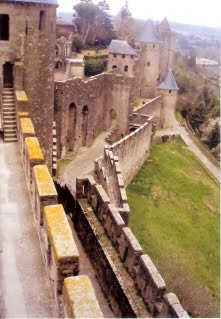
Historic Fortified City of Carcassonne

Card No 124Many thanks to my FB friend Gabriel Alejandro Etinzon

Carcassonne is a fortified French town in the Aude department, of which it is the prefecture, in the former province of Languedoc.
It is divided into the fortified Cité de Carcassonne and the more expansive lower city, the ville basse. Carcassone was founded by the Visigoths in the fifth century, though the Romans had fortified the settlement earlier. First signs of settlement in this region have been dated to about 3500 BC, but the hill site of Carsac – a Celtic place-name that has been retained at other sites in the south – became an important trading place in the 6th century BC. Read more

Monday, November 7, 2011

Iguaçu National Park

Card No 123Many thanks to my FB friend Gabriel Alejandro Etinzon

Created by federal decree nr. 1035 of January 10, 1939, the Park comprises a total area of 185,262.5 hectares and a length of about 420km, 300km of which are natural borders by bodies of water and the Brazilian and Argentinean sides together comprise around 225 thousand hectares.
On November 17, 1986, during the UNESCO conference held in Paris, the Iguaçú National Park was listed as Natural Heritage of Humanity and is one of the largest forest preservation areas in South America.
The Iguaçú National Park owes its name to the fact it includes an important area of the Iguaçú river, approximately 50km of the length of the river and the world famous Iguaçú Falls.
Read more

Information Obtained From Wikipedia, the free encyclopedia

Iguazu National Park

Card No 122Many thanks to my FB friend Gabriel Alejandro Etinzon

The semicircular waterfall at the heart of this site is some 80 m high and 2,700 m in diameter and is situated on a basaltic line spanning the border between Argentina and Brazil. Made up of many cascades producing vast sprays of water, it is one of the most spectacular waterfalls in the world. The Iguazú River ends in the Paraná River 23 km beyond the falls, after a 1320 km course. Inside the park it becomes up to 1,500 m wide and turns first south, then north, forming a large U-shape. Read More

Information Obtained from From Wikipedia, the free encyclopedia & UNESCO

Monday, October 31, 2011

Petra

card No 121
Many thanks to my FB friend Gabriel Alejandro Etinzon
Petra is a historical and archaeological city in the Jordanian governorate of Ma'an that is famous for its rock cut architecture and water conduits system. Established sometime around the 6th century BC as the capital city of the Nabataeans, it is a symbol of Jordan as well as its most visited tourist attraction. It lies on the slope of Mount Hor in a basin among the mountains which form the eastern flank of Arabah (Wadi Araba), the large valley running from the Dead Sea to the Gulf of Aqaba. Petra has been a UNESCO World Heritage Site since 1985. Read more

Information Obtained From Wikipedia, the free encyclopedia

Historic Quarter of the City of Colonia del Sacramento

Card No 120
Many thanks to my FB friend Gabriel Alejandro Etinzon

Founded by the Portuguese in 1680 on the Río de la Plata, the city was of strategic importance in resisting the Spanish. After being disputed for a century, it was finally lost by its founders. The Historic Quarter of the City of Colonia del Sacramento bears remarkable testimony in its layout and its buildings to the nature and objectives of European colonial settlement, in particular during the seminal period at the end of the 17th century. Read more

Thursday, October 20, 2011

Vatican City

Card No 119

Many thanks to my FB friend Gabriel Alejandro Etinzon

Vatican City was established in 1929 by the Lateran Treaty, signed by Cardinal Secretary of State Pietro Gasparri, on behalf of the Holy See and by Prime Minister Benito Mussolini on behalf of the Kingdom of Italy. Vatican City State is distinct from the Holy See, which dates back to early Christianity and is the main episcopal see of 1.2 billion Latin and Eastern Catholic adherents around the globe. Ordinances of Vatican City are published in Italian; official documents of the Holy See are issued mainly in Latin. Read more

Christ the Redeemer (statue), Brazil

Card No. (1)

Many thanks to my FB friend Gabriel Alejandro Etinzon

Christ the Redeemer is a statue of Jesus Christ in Rio de Janeiro, Brazil; considered the largest Art Deco statue in the world and the 5th largest statue of Jesus in the world.
It is 39.6 metres (130 ft) tall, including its 9.5 metres (31 ft) pedestal,
30 metres (98 ft) wide.
It weighs 635 tonnes (625 long,700 short tons),
located at the peak of the 700-metre (2,300 ft) Corcovado mountain in the Tijuca Forest National Park overlooking the city. A symbol of Christianity, the statue has become an icon of Rio and Brazil. It is made of reinforced concrete and soapstone, and was constructed between 1922 and 1931. Read more

LinkWithin

Related Posts with Thumbnails