Total Pageviews

Showing posts with label Turkey-UNESCO. Show all posts

Monday, March 1, 2010

Archaeological Site of Troy

Card # 59 This postcard sent to me by Cuneyt

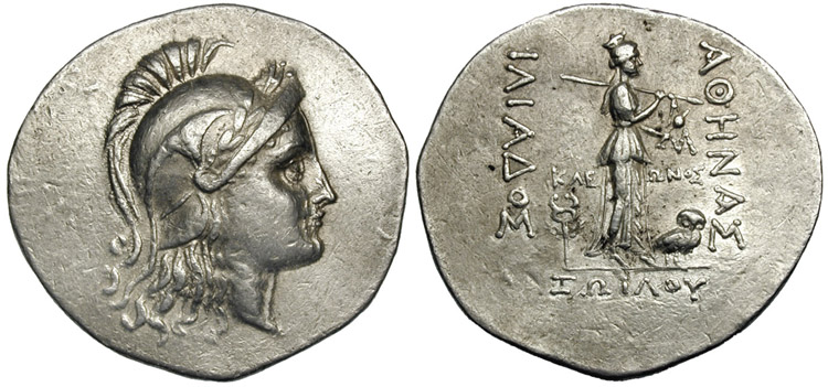
Silver tetradrachm from Troy during the Hellenistic period, 188–160 BC. Head of Athena in Attic helmet. Reverse female figure and owl with inscription: ΑΘΗΝΑΣ ΙΛΙΑΔΟΣ, ΚΛΕΩΝΟΣ ΙΛΙΟΥ, "Athénas Iliados, kleōnos Iliou".

A new city of Ilium was founded on the site in the reign of the Roman Emperor Augustus. It flourished until the establishment of Constantinople and declined gradually during the Byzantine era.

In 1865 an English archaeologist, Frank Calvert, excavated trial trenches in a field he had bought from a local farmer at Hisarlık, near Truva and in 1868 a wealthy German businessman, Heinrich Schliemann, after a chance meeting between the two men in Çanakkale town, also began excavating in this area.[2][3] Later excavations revealed several cities built in succession to each other. One of the earlier cities (Troy VII) is generally identified with Homeric Troy. While such an identity is disputed, the site has been successfully identified with the city called Wilusa in Hittite texts; Ilion (which goes back to earlier Wilion with a digamma) is thought to be the Greek rendition of that name. Read more

The archaeological site of Troy was added to the UNESCO World Heritage list in 1998.

Information and Image Obtained From Wikipedia, the free encyclopedia

Sunday, February 28, 2010

Nemrut Dağ

Card # 58 This postcard sent to me by Cuneyt


When the Seleucid Empire was defeated by the Romans in 189 BCE at the Battle of Magnesia it began to fall apart and new kingdoms were established on its territory by local authorities. Commagene being one of the Seleucid successor states occupied a land in between the Taurus mountains and the Euphrates. The state of Commagene had a wide range of cultures which left its leader from 62 BCE - 38 BCE Antiochus I to carry on a peculiar dynastic religious program, in which it included not only Greek and Persian deities but Antiochus and his family as well. This religious program was very possibly an attempt of Antiochus to unify his multiethnic kingdom and secure his dynasty's authority.

Some of the statues near the peak of Mount Nemrut

Antiochus supported the cult as a propagator of happiness and salvation. Many of the monuments on Mount Nemrud are ruins of the imperial cult of Commagene. The most important area to the cult was the tomb of Antiochus I, in which was decorated with colossal statues made of limestone. Although the Imperial cult did not last long after Antiochus, several of his successors had their own tombs built on Mount Nemrud. For about a half a year Mount Nemrud lays covered in snow which in effect has increased its weathering in which has in part caused its statues to fall in ruin. Read more
Information and Image Obtained From Wikipedia, the free encyclopedia

Monday, October 19, 2009

Historic Areas of Istanbul

Card # 31
These greatest historic postcard sent to me by my friend Cuneyt Ozarikan
1- Sultanahmet Camii ve Ayasofya
2- Dolmabahce Sarayi
3- Tophane, Karakoy
4- Yeni Camii, Galata Koprusu ve Bogaz
5- Faith Sultan Mehmet Koprusu
6- Ortakoy Camii ve Ortakoy

Istanbul largest and megacity in turkey. This beautiful historic city was added in UNESCO World Heritage List in 1985. In its long history, Istanbul has served as the capital city of the Roman Empire (330–395), the East Roman (Byzantine) Empire (395–1204 and 1261–1453), the Latin Empire (1204–1261), and the Ottoman Empire (1453–1922). The city was chosen as joint European Capital of Culture for 2010. Read more

Tuesday, September 15, 2009

Cappadocia and Uchisar- Turkey

Card # 211. Uchisar Koyu- Uchisar Village
2. Gorkun Dere Vadisi- Gorkun Dere Valley
3. Kaya Formasyonlari- Rock Formation

Uchisar Kaya Yerlesmeleri- Uchisar Rock-cut settlements

These postcard was sent to me by my friend Cuneyt Ozarikan

Cappadocia, the name was traditionally used in Christian sources throughout history and is still widely used as an international tourism concept to define a region of exceptional natural wonders characterized by fairy chimneys (image below) and a unique historical and cultural heritage. The term, as used in tourism, roughly corresponds to present-day Nevşehir Province of Turkey.

Cappadocia's limits are debated. In the time of Herodotus, the Cappadocians are supposed to have occupied the whole region from Mount Taurus to the vicinity of the Euxine (Black Sea). Cappadocia, in this sense, was bounded in the south by the chain of Mount Taurus, to the east by the Euphrates, to the north by Pontus, and to the west by Lake Tuz, in Central Anatolia. But Strabo, the only ancient author to provide a major account of the area, greatly exaggerated its dimensions. It is now believed that 400 km (250 mi) east-west by 200 km (120 mi) north-south is a more realistic appraisal of Cappadocia's area.

The earliest record of the name of Cappadocia dates from the late 6th century BC, when it appears in the trilingual inscriptions of two early Achaemenid kings, Darius I and Xerxes, as one of the countries which are part of the Persian Empire. Read more

Uchisar is situated at the highest point in the region, on the Nevsehir-Goreme road, just 7 km from Nevsehir. It is not known when Uchisar was first inhabited , however, in style, it resembles Ortahisar and the Selime Kalesi (castle) in the Ihlara Region. The top of the citadel provides a magnificent panorama of the surrounding area. Many rooms hollowed out into the rock are connected to each other with stairs, tunnels and passages. At the entrances of the rooms, there are millstone doors, just like the ones in the underground settlements, used to control access to these places. Due to the erosion in places of this multi-leveled castle, it is unfortunately not possible to reach all the rooms. The fairy chimneys to the west, east and north of Uchisar were hollowed out and used as graves during the Roman period. Inside these rock cut tombs, the entrances of which generally face west, are klines or stone slabs on which the bodies were laid. Many rock cut churches have been discovered not only on the skirts of the castle but also inside it. The reason for this may be the fact that Goreme, having numoreus churches and monasteries, is very close to Uchisar. The simple Byzantine graves on top of the castle are not very interesting due to the fact that they have been eroded and ransacked. It is said that in towns with citadels, e.g. Uchisar, Ortahisar and Ürgüp (Bashisar), long defense tunnels reached far into the surrounding areas. However, since the tunnels have collapsed in places, this theory cannot be confirmed, but is a popular myth as to the great distances they cover. Read more

Information obtained from Cappadocia online and Wikipedia, the free encyclopedia

Thursday, July 23, 2009

Kapadokya and Fairy chimneys in Urgup, Turkey

Card # 7

These postcard was sent to me by my friend Cuneyt Ozarikan

The first populations of the region of Cappadocia were Hatties, Luvies and Hittites. In the 3000-2000 years B.C. the Assyrians have established trade colonies in this region. In 33 b.c. the Big Alexander has captured a big part of Cappadocia. In 188 B.C. The Cappadocia which entered under the Roman domination has been captured in 100 B.C. by the Mithridatesd the king of Pontus but in 63 B.C. Pompeius has defeated Mithridates and took again the Cappadocia under the domination of Rome. In the period of Tiberius the Cappadocia gainded the status of Roman distric. Cappadocia was one of the most important places in the spreading periods of the Christian religion. In 647 A.C. together with occupation of Kayseri by Muaviye Cappadocia has met with the Arabian invasions. Cappadocia which went under the domination of the Seljuks in 1072 has been added to the lands of Ottoman Empire in 1399 by the Ottoman Sultan Yildirim Beyazit. Became UNESCO World Heritage Site in 1985.
Information Obtained from cappadociaturkey.net


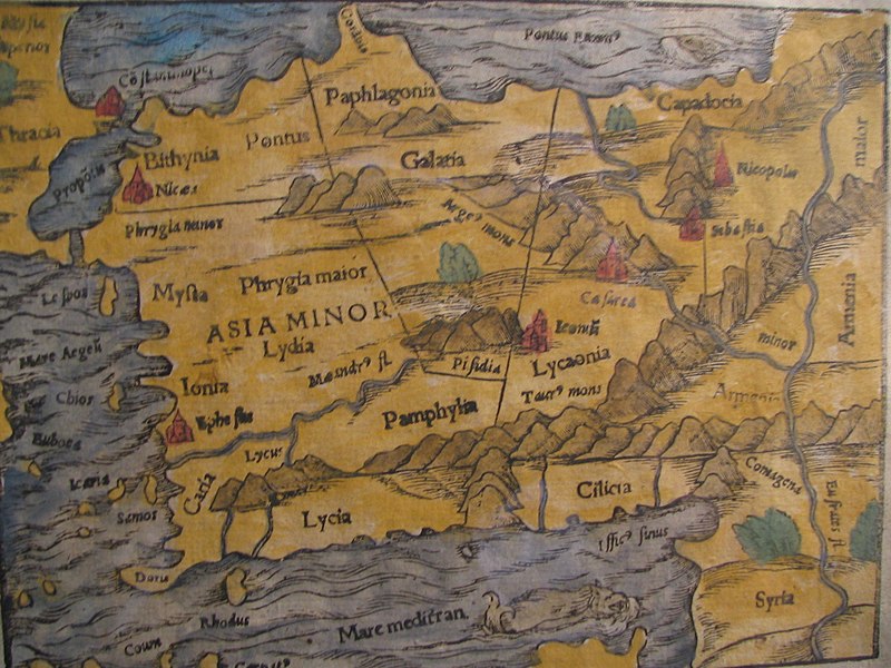
15th century map of Turkey region
Image Obtained From Wikipedia, the free encyclopedia

Historical area of Istanbul-Topkapi Palace, Turkey

Card # 6
These postcard was sent to me by my friend Cuneyt Ozarikan

Topkapi palace was initial constructed by Faith Sultan Mehmet ll, in 1459. Is a offically residence of the Ottoman Sultans for 400 years from 1465 to 1853. The palace containing of most holy relics of the Muslim such as prophet Muhammed's clock and sword. In 1985 it became a UNESCO World Heritage Site. It has four courtyards and home for many as 4,000 people. The complex has been expanded over the centuries, with many renovations such as after the 1509 earthquake and 1665 fire. It held mosques, a hospital, bakeries, and mint. Topkapı Palace gradually lost its importance at the end of the 17th century, as the Sultans preferred to spend more time in their new palaces along the Bosporus. In 1921 after the end of Ottomon Sultan Empire, government transformed into a museum of the imperial era in April 3, 1924 and it's under the administration of the Ministry of Culture and Tourism. Even the palace has hundreds of chambers and room only important are allowed for the public today, guarded by offical and armed guards of Turkish military.

Tuesday, July 21, 2009

Hierapolis-Pamukkale, Turkey

Card # 2
These postcard was sent to me by my friend Cuneyt Ozarikan

Is a cotton castle in Turkish is located in Turkey's inner Aegean region. Pamukkale is a tourist attraction. It is recognized as a World Heritage Sites together with Hierapolis. Hierapolis-Pamukkale was made a World Heritage Site in 1988. At the end of the 2nd century B.C. the dynasty of the Attalids, the kings of Pergamon, established the thermal spa of Hierapolis. The ruins of the baths, temples and other Greek monuments can be seen at the site.
Hot springs of Pamukkale
Image Obtained From Wikipedia, the free encyclopedia

LinkWithin

Related Posts with Thumbnails