Total Pageviews

Sunday, February 28, 2010

Mill Network at Kinderdijk-Elshout

Card # 56 Another WH-UNESCO postcard from postcrossing, Marleen

Kinderdijk is a village in the Netherlands, belonging to the municipality of Nieuw-Lekkerland, in the province South Holland, about 15 km east of Rotterdam.

Kinderdijk is situated in a polder at the confluence of the Lek and Noord rivers. To drain the polder, a system of 19 windmills was built around 1740. This group of mills is the largest concentration of old windmills in the Netherlands.

The windmills of Kinderdijk are one of the best known Dutch tourist sites. They were placed on the list of UNESCO list of World Heritage Sites in 1997. Read more

Information Obtained From Wikipedia, the free encyclopedia

Thursday, February 25, 2010

Old City of Dubrovnik

Card # 55
This postcard sent to me by Goran

Dubrovnik is a Croatian city on the Adriatic Sea coast in the extreme south of Dalmatia, positioned at the terminal end of the Isthmus of Dubrovnik. It is one of the most prominent tourist destinations on the Adriatic, a seaport and the center of Dubrovnik-Neretva county. Its population was 43,770 in 2001 down from 49,728 in 1991. In 1979, the city of Dubrovnik joined the UNESCO list of World Heritage Sites.

In Croatian, and all other Slavic languages, the city is known as Dubrovnik; in Italian as Ragusa, its historical name, in Greek as Raiyia (Ραυγια) or Ragousa (Ραγουσα).

The current Croatian name was officially adopted in 1918 after the fall of Austria–Hungary. Historical lore indicates that Ragusa (Dubrovnik) was founded in the 7th century on a rocky island named Laus, which provided shelter for Dalmatian refugees from the nearby city of Epidaurus. The Latino-dalmatian founders were escaping from the Slavic invasions.

Rooftops in Dubrovnik's Old City, a UNESCO World Heritage Site. Read more

The RED rooftop really very beautiful view.

Tuesday, February 23, 2010

Fortress of Suomenlinna

Card # 54 This postcard sent to me by Satu

Suomenlinna, until 1918 Viapori (Finnish), or Sveaborg (Swedish), is an inhabited sea fortress built on six islands (Kustaanmiekka, Susisaari, Iso-Mustasaari, Pikku-Mustasaari, Länsi-Mustasaari and Långören), and which is nowadays part of Helsinki, the capital of Finland.

Suomenlinna is a UNESCO World Heritage site and popular with both tourists and locals, who enjoy it as a picturesque picnic site. Originally named Sveaborg (Fortress of Svea), or Viapori as called by Finns, it was renamed Suomenlinna (Castle of Finland) in 1918 for patriotic and nationalistic reasons, though it is still also sometimes known by its original name. In Swedish-speaking contexts, the name Sveaborg is usually used.

The Swedish crown commenced the construction of the fortress in 1748 as protection against Russian expansionism. The general responsibility for the fortification work was given to Augustin Ehrensvärd. The original plan of the bastion fortress was strongly influenced by the ideas of Vauban, the foremost military engineer of the time, and the principles of Star Fort style of fortification, albeit adapted to a group of rocky islands.

In addition to the island fortress itself, seafacing fortifications on the mainland would ensure that an enemy would not acquire a beach-head from which to stage attacks. The plan was also to stock munitions for the whole Finnish contingent of the Swedish Army and Royal Swedish Navy there. In the Finnish War the fortress surrendered to Russia on May 3 1808, paving the way for the occupation of Finland by Russian forces in 1809. Read more

Old Rauma

Card # 53This postcard sent to me by Simi, 3rd UNESCO postcard from Postcrossing


Old Rauma (Finnish: Vanha Rauma) is the wooden city centre of the town of Rauma, Finland. It is listed as a Unesco world heritage site.

The area of Old Rauma is about 0.3 km², with approximately six hundred buildings (counting both proper houses and smaller buildings like sheds) and about 800 people living in the area. The town of Rauma expanded outside the Old Rauma proper only in the early 1800s. The oldest buildings date from the 18th century, as two fires of 1640 and 1682 destroyed the town. Most buildings are currently inhabited and owned by private individuals, although along the two main streets and around the town square they are mainly in business use.

Locations of special interest include the Kirsti house, which is a seaman's house from the 18th and 19th centuries, and the Marela house, which is a shipowner's house dating to the 18th century but with a 19th century facade, both of which are currently museums. Other sights include the rare stone buildings of the Old Rauma: the Church of the Holy Cross, an old Franciscan monastery church from the 15th century with medieval paintings and the old town hall from 1776. Another church in Rauma, the Church of the Holy Trinity, also from the 15th century, burned in the fire of 1640.

Information Obtained From Wikipedia, the free encyclopedia

Carlsbad Caverns National Park

Card # 52 This Postcard sent to me by Jean

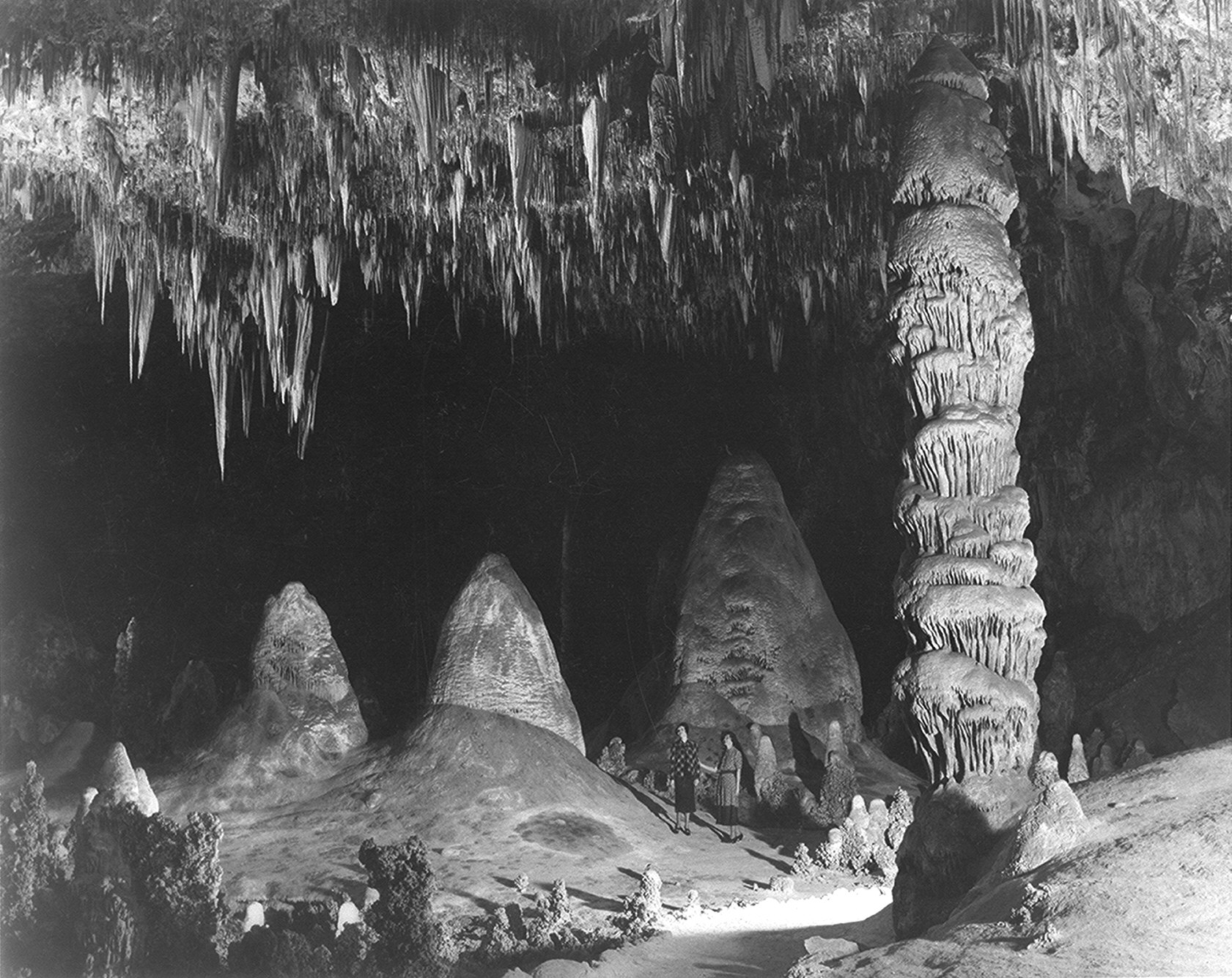
Carlsbad Caverns National Park is a United States National Park in the Guadalupe Mountains in southeastern New Mexico. The primary attraction of the park for most visitors is the show cave, Carlsbad Caverns. Visitors to the cave can hike in on their own via the natural entrance, or take the elevator (the exit for everyone) directly to the Underground Lunchroom some 750 feet (230 m) below.

Rock of Ages in the Big Room, photo by Ansel Adams, c. 1941

Carlsbad Caverns includes a large cave chamber 3rd largest in the Americas and 7th largest in the world, the Big Room, a natural limestone chamber which is almost 4,000 feet (about 1,219 m) long, 625 feet (190.5 m) wide, and 350 feet (about 107 m) high at the highest point. The largest in the world is the Sarawak Chamber in Malaysia. Read more

Information and Image Obtained From Wikipedia, the free encyclopedia

Thursday, February 4, 2010

Cathedral of Notre-Dame, Former Abbey of Saint-Remi and Palace of Tau, Reims

Card #51
This postcard sent to me by Christian

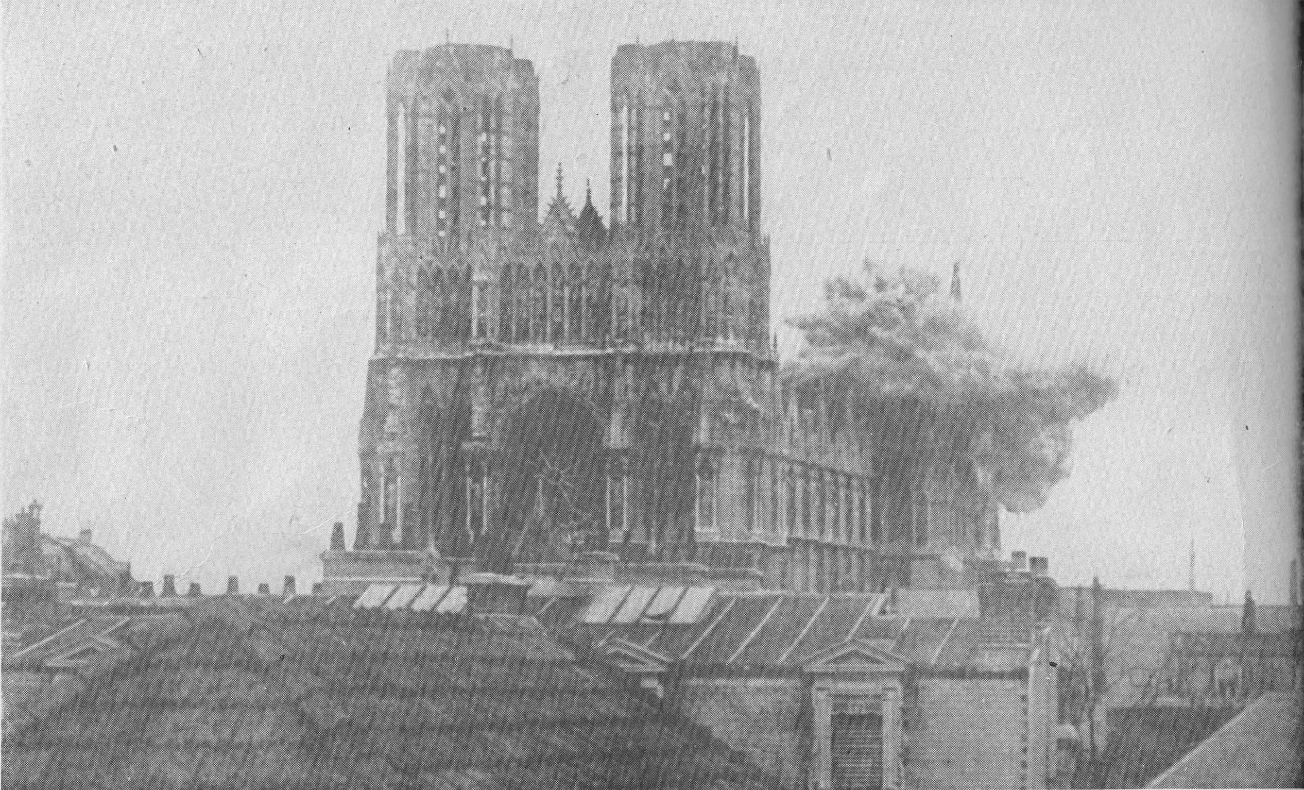
Notre-Dame de Reims (Our Lady of Rheims) is the Roman Catholic cathedral of Reims, where the kings of France were once crowned. It replaces an older church, destroyed by a fire in 1211, which was built on the site of the basilica where Clovis was baptized by Saint Remi, bishop of Reims, in AD 496. That original structure had been erected on the site of the Roman baths. As the cathedral it remains the seat of the Archdiocese of Reims. Notre-Dame de Reims cathedral, the former Abbey of Saint-Remi, and the Palace of Tau were added to the list of UNESCO World Heritage Sites in 1991.

A major site for tourism in the Champagne region, it accommodated half a million visitors in 2006. Read more

A shell bursts on the cathedral during the First World War

Links: Cathedral of Notre-Dame, Reims

Information and Image Obtained From Wikipedia, the free encyclopedia

Wednesday, February 3, 2010

50 World Heritage Postcard

50!!

YEH!!!!!! Super duper!!!! finally reached to 50 WH UNESCO postcards
MY dear wonderful friends thank you very very much for the kind help
on my collection....!!!!:)

Sacred City of Kandy

Card # 50
This postcard sent to me by Aravinda Babu

The Sri Dalada Maligawa or The Temple of the Sacred Tooth Relic is a temple in the city of Kandy in Sri Lanka. It was built within the royal palace complex which houses the only surviving relic of Buddha, a tooth, which is venerated by Buddhists. The relic has played an important role in the local politics since ancient times, it's believed that whoever holds the relic holds the governance of the country, which caused the ancient kings to protect it with great effort. Kandy was the capital of the Sinhalese Kings from 1592 to 1815, fortified by the terrain of the mountains and the difficult approach. The city is a world heritage site declared by UNESCO, in part due to the temple.

Monks of the two chapters of Malwatte and Asgiriya conduct daily ritual worship in the inner chamber of the temple, in annual rotation. They conduct these services three times a day: at dawn, at noon and in the evening.

On Wednesdays there is a symbolic bathing of the Sacred Relic with an herbal preparation made from scented water and flagrant flowers, called Nanumura Mangallaya. This holy water is believed to contain healing powers and is distributed among those present. Read more

Historical records suggest that Kandy was first established by the King Wickramabahu (1357–1374 CE) near the Watapuluwa area, north of the present city, and named Senkadagalapura at the time, although some scholars suggest the name Katubulu Nuwara may also have been used. The origin of the more popular name for the city, Senkadagala, could have been from a number of sources. These include naming after a brahmin named Senkanda who lived in a cave near the city, after a queen of King Wickramabahu named Senkanda or after a colored stone named Senkadagala.


Links: Welcome to the World Heritage Kandy City

Information and Image Obtained From Wikipedia, the free encyclopedia

The Wadden Sea

Card # 49
This postcard sent to me by Wilhelm, 2nd UNESCO postcard from Postcrossing

The Wadden Sea is an intertidal zone in the southeastern part of the North Sea. It lies between the coast of northwestern continental Europe and the range of Frisian Islands, forming a shallow body of water with tidal flats and wetlands. It is rich in biological diversity. In 2009, the Dutch and German parts of the Wadden Sea were inscribed on UNESCO's World Heritage List.


The Wadden Sea stretches from Den Helder in the Netherlands in the southwest, past the great river estuaries of Germany to its northern boundary at Skallingen north of Esbjerg in Denmark along a total length of some 500 km and a total area of about 10,000 km².

The islands in the Wadden Sea are called the Wadden Sea Islands or Frisian Islands, named after the Frisians. However, on the westernmost Dutch island, Texel, the Frisian language has not been spoken for centuries. The Danish Wadden Sea Islands have never been inhabited by Frisians. The outlying German island of Heligoland, although ethnically one of the Frisian Islands, is not situated in the Wadden Sea. Read more

Fortifications of Vauban

Card # 48
This postcard sent to me by Christian

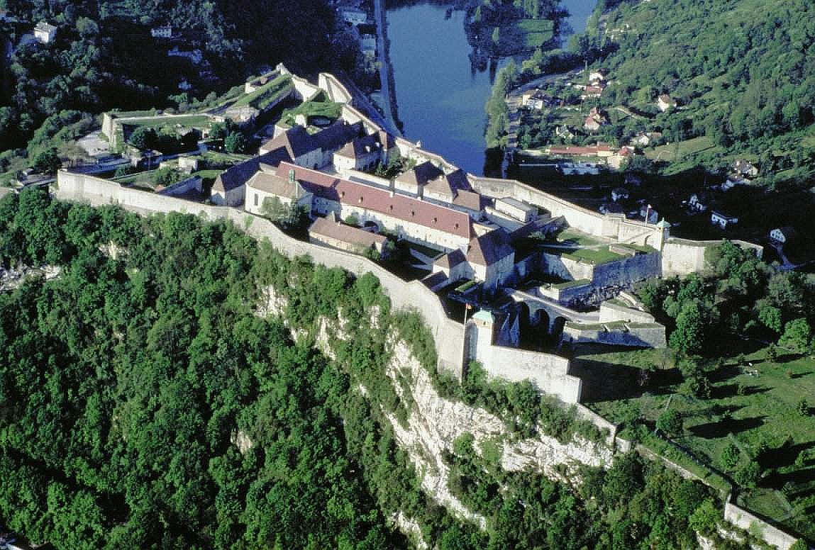
Fortifications of Vauban consists of 12 groups of fortified buildings and sites along the western, northern and eastern borders of France. They were designed by Vauban (1633–1707), and were added in 2008 to the list of UNESCO World Heritage Sites.

Citadel of Besançon (Doubs), 1668-1711

Information and Image Obtained From Wikipedia, the free encyclopedia

Qutb Minar and its Monuments, Delhi

Card # 47
This postcard sent to me by Commodore Vijay Kapre

The Qutb Minar a tower in Delhi, India, is at 72.5 meters the world's tallest brick minaret. It is situated in the Qutb complex, amidst the ruins of ancient Hindu & Jain temples which were destroyed and their stones used to build the Qutb complex and minar. Construction commenced in 1193 under the orders of India's first Muslim ruler Qutb-ud-din Aibak, and the topmost storey of the minaret was completed in 1386 by Firuz Shah Tughluq. The Qutb Minar is notable for being one of the earliest and most prominent examples of Indo-Islamic architecture.

It is surrounded by several other ancient and medieval structures and ruins, collectively known as Qutb complex. The complex is listed as a UNESCO World Heritage Site and is one of the most popular tourist destinations in Delhi, and was also India's most visited monument in 2006, as it attracted 3.9 million visitors, even more than the Taj Mahal, which drew about 2.5 million visitors. At 72.5 m (234 ft), the Qutub Minar is the world's tallest free standing minaret.

Read more

Information and Image Obtained From Wikipedia, the free encyclopedia

Sunday, January 10, 2010

Kinabalu Park

Card # 46
This postcard sent to me by Caroline Chia

Kinabalu National Park or Taman Negara Kinabalu in Malay, established as one of the first national parks of Malaysia in 1964, is Malaysia's first World Heritage Site designated by UNESCO in December 2000 for its "outstanding universal values" and the role as one of the most important biological sites in the world. Located on the west coast of Sabah, east Malaysia on the island of Borneo; it covers an area of 754 square kilometers surrounding Mount Kinabalu, which at 4,095.2 metres, is the highest mountain on the island of Borneo. The park is one of the most popular tourist spot in Sabah as well as in Malaysia. In 2004, more than 415,360 visitors and 43,430 climbers visited the Park. Read more

Information Obtained From Wikipedia, the free encyclopedia

Historic Centre of Warsaw

Card # 45 This postcard sent to me by Kazimierz

Warsaw's Old Town was established in the 13th century. Initially surrounded by an earthwork rampart, prior to 1339 it was fortified with brick city walls. The town originally grew up around the castle of the Dukes of Mazovia that later became the Royal Castle. The Market Square (Rynek Starego Miasta) was laid out sometime in the late 13th or early 14th century, along the main road linking the castle with the New Town to the north.

Until 1817 the Old Town's most notable feature was the Town Hall built before 1429. In 1701 the square was rebuilt by Tylman of Gameren, and in 1817 the Town Hall was demolished. Since the 19th century, the four sides of the Market Square have borne the names of four notable Poles who once lived on the respective sides: Ignacy Zakrzewski (south), Hugo Kołłątaj (west), Jan Dekert (north) and Franciszek Barss (east). Read more

Project of rebuilding the Royal Castle, 1843 by Adam Idźkowski.

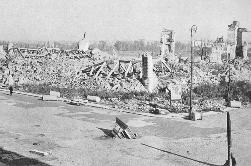
Royal Castle in 1945. It was deliberately destroyed by the Germans in 1944.

The Castle Today


Information and Image Obtained From Wikipedia, the free encyclopedia

Wulingyuan Scenic and Historic Interest Area

Card # 44 This postcard sent to me by one Chinese friend

Wulingyuan is a scenic and historic interest area in Hunan Province, China, famous for its approximately 3,100 tall quartzite sandstone pillars, some over 800 meters in height, which are a kind of karst formation. It is part of Zhangjiajie city, about 270km from the capital of Hunan Province, Changsha. It lies between the coordinates of 29°16′0″N 110°22′0″E / 29.266667°N 110.366667°E / 29.266667; 110.366667Coordinates: 29°16′0″N 110°22′0″E / 29.266667°N 110.366667°E / 29.266667; 110.366667 and 29°24′0″N 110°41′0″E / 29.4°N 110.683333°E / 29.4; 110.683333. It was designated a UNESCO World Heritage Site in 1992. Wulingyuan forms part of the Wuling Range.

Information Obtained From Wikipedia, the free encyclopedia

Mount Wuyi

Card # 43
This postcard sent to me by one Chinese friend.

The mountains cover an area of 60 km². In 1999, Mount Wuyi entered UNESCO's list of World Heritage Sites, both natural and cultural. It is the most outstanding biodiversity conservation zone of Southeast China. Numerous types of tea are produced around Mount Wuyi; it is the origin of the real Da Hong Pao tea and Lapsang souchong, further described in Wuyi tea. Read more

The Yunu hill, the "symbol" of Wuyi Mountains

Information and Image Obtained From Wikipedia, the free encyclopedia

Tuesday, December 29, 2009

Centennial Hall in Wrocław

Card # 42
This postcard sent to me by Kazimierz

It was in the Lower Silesian capital of Breslau on 10 March 1813 that King Frederick William III of Prussia called upon the German people in his "Aufruf an mein Volk" to rise up against Napoleon's occupation of Germany. In October of that year, in the Battle of Leipzig at Leipzig, Napoleon was defeated. The opening of the hall was part of the celebration commemorating the 100th anniversary of the battle, hence the name. The hall was renamed Hala Ludowa ("People's Hall") when the city became part of Poland under a communist government in 1945. The Polish translation of the original German name, Hala Stulecia, is also used with reference to the history of the building.

The cupola was made of reinforced concrete and with an inner diameter of 69 m and 42 m high; it was the largest building of its kind at the time of construction. The symmetrical quatrefoil shape with a large circular central space seats 7,000 persons. The dome is 23m high, made of in steel and glass. The Jahrhunderthalle became a key reference for the development of reinforced concrete structures in the a 20th century. Read more

Historic City of Toledo

Card # 41
This postcard sent to me by Emilio Fernandez Esteban

Toledo is a municipality located in central Spain, 70 km south of Madrid. It is the capital of the province of Toledo and of the autonomous community of Castile-La Mancha. It was declared a World Heritage Site by UNESCO in 1986 for its extensive cultural and monumental heritage as one of the former capitals of the Spanish Empire and place of coexistence of Christian, Jewish and Moorish cultures. Many famous people and artists were born or lived in Toledo, including Al-Zarqali, Garcilaso de la Vega, Eleanor of Toledo, Alfonso X and El Greco. It was also the place of important historic events such as the Visigothic Councils of Toledo.

Old city of Toledo

Having been populated since the Bronze Age, Toledo gained relevance during Roman times, being a main commercial and administrative center in the roman province of Tarraconensis. After the fall of the Roman Empire, Toledo served as the capital city of Visigothic Spain, beginning with Liuvigild and was the capital of Spain until the Moors conquered Iberia in the 8th century. Read more

40 World Heritage Postcard!!!Hurray!!!

Hurray!!!! collected 40 World Heritage Postcards so far......:)))) thAnK YoU aLLL my dEaR FrIeNDsssssssss

Petäjävesi Old Church

Card # 40 This postcard sent to me by Artlover

The Petäjävesi Old Church (Finnish: Petäjäveden vanha kirkko) is a wooden church located in Petäjävesi, Finland. It was inscribed in 1994 on the UNESCO World Heritage List. It was built between 1763 and 1765. UNESCO considered it to be a representative Lutheran church of the Scandinavian tradition, mixing Renaissance with older Gothic elements. Information Obtained From Wikipedia, the free encyclopedia

LinkWithin

Related Posts with Thumbnails