Card No. 150

The mountain summits are of great significance to the local Māori.In 1886 in order to prevent the selling of the mountains to European settlers, the local Ngati Tuwharetoa iwi had the mountains surveyed in the Native Land Court and then set aside (whakatapua) as a reserve in the names of certain chiefs one of whom was Te Heuheu Tukino IV (Horonuku), the most significant chief of the Māori Ngati Tuwharetoa iwi. Later the peaks of Mount Tongariro, Mount Ngauruhoe, and parts of Mount Ruapehu, were conveyed to The Crown on 23 September 1887, on condition that a protected area was established there.
This 26.4 km² area was generally considered to be too small to establish a national park after the model of Yellowstone National Park in Wyoming (USA), and so further areas were acquired. When the Parliament of New Zealand passed the Tongariro National Park Act in October 1894, the park covered an area of about 252.13 km², but it took until 1907 to acquire the land. When the Act was renewed in 1922, the park area was extended to 586.8 km². Further extensions, especially Pihanga Scenic Reserve in 1975, enlarged the park to its current size of 795.98 km². The last modification to the Act was passed in 1980. Tongariro National Park has been under the control of the New Zealand Department of Conservation since the creation of the department in 1987.
The first activities in the young Tongariro National Park were the construction of tourist huts at the beginning of the 20th century. But it was not before opening of the railway in 1908 and the building of roads in the 1930s that a significant number of people visited the park. The second Tongariro National Park Act, in 1922, started some active conservation efforts, but it was not until 1931 that the first permanent park ranger began work. Road construction into Whakapapa valley had already begun in the 1920s. The first ski hut was built in 1923 at an elevation of 1770 m, thereafter a road, and, in 1938, a ski lift in the area. This early tourist development explains the rather uncommon existence of a permanently inhabited village and fully developed ski area within a national park. The hotel Chateau Tongariro, which is still the centre of Whakapapa today, was established in 1929.
In the early 20th century, park administrators introduced heather to the park, for grouse hunting. Grouse were never actually introduced, but the heather is sprawling, threatening the ecological system and endemic plants of the park. Efforts are being made to control the plant's spread, however complete eradication seems unlikely. Tongariro National Park is the oldest national park in New Zealand, located in the central North Island. It has been acknowledged by UNESCO as one of the 28 mixed cultural and natural World Heritage Sites.
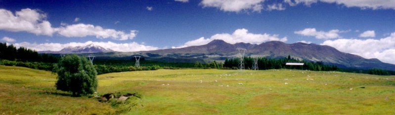
Tongariro National Park was the fourth national park established in the world. The active volcanic mountains Ruapehu, Ngauruhoe, and Tongariro are located in the centre of the park.
There are a number of Māori religious sites within the park and the summits of Tongariro, including Ngauruhoe and Ruapehu, are tapu (sacred). The park includes many towns around its boundary including Ohakune, Waiouru, Horopito, Pokaka, Erua, National Park Village, Whakapapa skifield and Turangi. Read more
Information and Image Obtained From Wikipedia, the free encyclopedia
No comments:
Post a Comment