Total Pageviews

Sunday, February 13, 2011

San Millán Yuso and Suso Monasteries

Card No. 104
Another UNESCO postcard by my postcrossing

The monasteries of San Millán de Suso and San Millán de Yuso are two monasteries situated in the village of San Millán de la Cogolla, La Rioja, Spain. There is a continuous history of Christianity at San Millán since the time of the saint. The scriptorium remained active during the period of Muslim rule; and over the centuries, the religious community has overcome various vicissitudes which affected the monasteries (for example being sacked by the Black Prince. Read more
Information Obtained From Wikipedia, the free encyclopedia

Tuesday, February 8, 2011

Sunday, February 6, 2011

St. Mary's Cathedral and St. Michael's Church at Hildesheim

Card no. 103
Another UNESCO postcard from postcrossing

The Church of St. Michael (German: Michaeliskirche) in Hildesheim, Germany, is an early-Romanesque church. Abbey Church of St. Michael's was constructed between 1001 and 1031 under the direction of Bishop Bernward of Hildesheim (993-1022) as the chapel of his Benedictine monastery. Bernward named the church after the archangel Michael, the Christian angel of protection who carries the deceased to heaven, because he planned to be buried in the Michaeliskirche[citation needed]. Bernward's plans were spoiled by his death in 1022, eleven years before the completion and consecration of the church in 1033. Bernward's successor, Godehard, transferred Bernward's remains to the crypt following its completion.
St. Michael's Church was destroyed in an air raid during World War II on 22 March 1945, but reconstruction was begun in 1950 and completed in 1957. In 1985, the church became a UNESCO World Cultural Heritage site, along with the Cathedral of Hildesheim, its collection of medieval treasures and its 1000-year old rosebush. Read more
Information Obtained From Wikipedia, the free encyclopedia

Festival of India, in U.K.

FDC No. 6
Issued by: Indian Post & Telegraphs 23 March 1982

First Day Cover Illustration: A part of Stupa railing in red stone from Bharhut belonging to middle of 2nd century B.C: Sunga period.

Bharhut or Barhut is a location in Satna district in Madhya Pradesh, Central India, known for its famous Buddhist stupa. The Bharhut stupa may have been established by the Maurya king Asoka in the 3rd century BCE, but many works of art were apparently added during the Sunga period, with many friezes from the 2nd century BCE. Read more
A relief from Barhut.

Yakshi reliefs. Bharhut, 2nd century BCE.

A yakshini is the female counterpart of the male yaksha, and they both attend on Kubera (also called Kuber), the Hindu god of wealth who rules in the mythical Himalayan kingdom of Alaka. They both look after treasure hidden in the earth and resemble that of fairies. Yakshinis are often depicted as beautiful and voluptuous, with wide hips, narrow waists, broad shoulders, and exaggerated, spherical breasts. In the Uddamareshvara Tantra, thirty-six yakshinis are described, including their mantras and ritual prescriptions. A similar list of yakshas and yakshinis is given in the Tantraraja Tantra, where it says that these beings are givers of whatever is desired. Although Yakshinis are usually benevolent, there are also yakshinis with malevolent characteristics in Indian folklore. Read more
Information and Image Obtained From Wikipedia, the free encyclopedia

India TANAPEX 75 Exhibition

SPC TANAPEX '75 No. 1
Issued by: Tamilnadu Postal 08 Sept 1975

First Day Cover Illustration: Mahabalipuram Sculpture
Information by my friend Kasinath. R
International and national level philatelic exhibitions, each state also will conduct state level philatelic exhibitions often throughout india and issue special covers to commemorate the event.
Tanapex refers to "TA"mil "NA"du "P"hilatelic "EX"hibition, held in 1975. The special cover issued by tamilnadu postal circle, also with special postmark.

Saturday, February 5, 2011

National Maritime Day

FDC No. 5
Issued by: Indian Post & Telegraphs 05 April 1965

First Day Cover Illustration: National Maritime Day

April 5 marks the National Maritime Day of India. On this day in 1919 navigation history was created when SS Loyalty, the first ship of the Scindia Steam Navigation Company, journeyed to the United Kingdom. The National Maritime Day was first celebrated on 5th April, 1964.

5th Battalion The Grenadiers

FDC No. 4
Issued by: The Army Postal Service 20 Oct 2010
First Day Cover Illustration: 50 Years, 5th Battalion The Grenadiers
The oldest Grenadier Regiment of the armies in the Commonwealth belongs to the Indian Army. A composite battalion comprising Grenadier companies of Bombay Sepoys won the famous battle of Talegaon in 1778. By 1784, the group of Grenadier companies had been given the title of Bombay Grenadiers. The concept of 'Grenadiers' evolved from the practice of selecting the bravest and strongest men for the most dangerous tasks in combat. The Grenadiers have one of the longest unbroken record of existence in the Indian Army.

Army Services Corps

FDC No. 3
Issued by: The Army Postal Service 08 Dec 2010

First Day Cover Illustration: 250 Years Army Service Corps


Rajput Regimental Center, Fatehgarh

FDC No. 2
Issued by: The Army Postal Service 20 Nov 2010


First Day Cover Illustration: 90 Glorious Years Rajput Regimental

The Rajput Regiment is a regiment in the Indian Army that is composed primarily of the Rajput clans from India. The British designated the Rajputs as a martial race and subsequently employed large numbers of these warriors in the British Indian Army.

The Rajput Regimental center is in Fatehgarh, Uttar Pradesh. The regiment nowadays recruits Rajputs, Gujjars, Hindu Bengalis, Ahirs, Muslims, Jats, Mazhabi & Ramdasia Sikhs and Dogras. A war memorial was erected at Fetehgarh in 1932. It is in a form of a chattri, with its dome resting on six pillars, each representing a battalion at that time and bearing its crest. The regimental motto is Sarvatra Vijaya, which means Victory Everywhere and the war cry is Bajrang Bali Ki Jai.
The association of the Rajputs with the British Indian Army started in 1778, when the 3rd Battalion was raised as the 31st Regiment Bengal Native Infantry. Two other battalions the 1st and 2nd were raised in 1798. Read more

Information Obtained From Wikipedia, the free encyclopedia

Bi-centenary of 7th Light Cavalry

FDC No. 1
Issued by: Indian Post & Telegraphs 07 Jan 1984

First Day Cover Illustration: The late Shri Jawaharlal Nehru Inspecting
the guard of honour of 7th Light Cavalry

The 7th Light Cavalry, was a regular army cavalry regiment in the British Indian Army , they first come into British service with the East India Company and went on to serve on the North West Frontier and in World War I and World War II. Read more

Friday, February 4, 2011

Meenakshi Temple, Madurai

India-89 WPE, Card no. 6
Meenakshi Sundareswarar Temple or Meenakshi Amman Temple is a historic Hindu temple located in the holy city of Madurai in India. The temple is a significant symbol for the Tamil people, and has been mentioned since antiquity in Tamil literature, though the present structure is believed to have been built in 1600 but Date built still unknown. Read more
Vishnu hands over his sister Meenakshi to Shiva.
Information and Image Obtained From Wikipedia, the free encyclopedia

Sher Shah's Tomb, Sasaram

India-89 WPE, Card no. 6
Sher Shah Suri Tomb is a tomb in Sasaram town in Bihar state in India. It was built in memory of Afghan Emperor Sher Shah Suri who ruled Delhi Northern India for five years, after defeating Humayun, the 2nd Mughal Emperor. Designed by the architect Aliwal Khan and built between 1540 and 1545, this red sandstone mausoleum (122 ft high), which stands in the middle of an artificial lake, which is nearly square, is known as the second Taj Mahal of India. Read more
Information Obtained From Wikipedia, the free encyclopedia

Qutb Minar and its Monuments

India-89 WPE, Card no. 5
Qutb Minar, Delhi

Group of Monuments at Mahabalipuram

India-89 WPE, Card no. 4
Mahabalipuram, Tamil Nadu

Tajmahal, Agra

India-89 WPE, Card no. 3
Tajmahal, Agra

Hawamahal, Jaipur

India-89 WPE, Card no. 2

Built of red and pink sandstone. Hawa Mahal is a palace in Jaipur, India. It was built in 1799 by Maharaja Sawai Pratap Singh, and designed by Lal Chand Usta in the form of the crown of Krishna, the Hindu god. Its unique five-storey exterior is also akin to the honeycomb of the beehive with its 953 small windows called jharokhas that are decorated with intricate lattice work.The original intention of the lattice was to allow royal ladies to observe everyday life in the street below without being seen, since they had to observe strict "purdah". It is particularly striking when viewed early in the morning, lit with the golden light of sunrise.

Hawa Mahal in 1875
Hawa Mahal now
Information and Image Obtained From Wikipedia, the free encyclopedia

The Red Fort Complex

India-89 WPE, Card no. 1

In 1989 next International exhibition named INDIA-89 was organised in New Delhi. The first International stamp exhibition in India was held in 1954 to commemorate 100 years of postage stamp in India. The design of, stylized Swan, regarded as a messenger of good news – adapted from the story of “Nala – Damayanti”.

The Red Fort is a 17th century fort complex constructed by the Mughal emperor Shah Jahan in the walled city of Old Delhi (in present day Delhi, India). It served as the capital of the Mughals until 1857, when Mughal emperor Bahadur Shah Zafar was exiled by the British Indian government. The British used it as a military camp until India was made independent in 1947, the Prime Minister of India raises the flag of India on the ramparts of the Lahori Gate of the fort complex every year on Independence Day. It was designated a UNESCO World Heritage Site in 2007. Mughal Emperor Shahjahan, started construction of the massive fort in 1638 and work was completed in 1648 (10 years). The Red Fort was originally referred to as "Qila-i-Mubarak" (the blessed fort), because it was the residence of the royal family. The layout of the Red Fort was organised to retain and integrate this site with the Salimgarh Fort. The fortress palace was an important focal point of the medieval city of Shahjahanabad. The planning and aesthetics of the Red Fort represent the zenith of Mughal creativity which prevailed during the reign of Emperor Shah Jahan. This Fort has had many developments added on after its construction by Emperor Shahjahan. The significant phases of development were under Aurangzeb and later Mughal rulers. Important physical changes were carried out in the overall settings of the site after the First War of Independence during British Rule in 1857. After Independence, the site experienced a few changes in terms of addition/alteration to the structures. During the British period the Fort was mainly used as a cantonment and even after Independence, a significant part of the Fort remained under the control of the Indian Army until the year 2003.The Red Fort is a tourist attraction from around the world. Read more

Information and Image Obtained From Wikipedia, the free encyclopedia

Friday, December 24, 2010

At once the angel was joined by huge angelic choir
singing God's praise:
"Glory to God in the heavenly heights,
Peace to all men and woman on earth who please him,''
Luke 2:13-14
****************************************
''A WONDERFUL & JOYOUS CHRISTMAS TO EVERYONE''

Wednesday, November 24, 2010

Wednesday, November 10, 2010

Rice Terraces of the Philippine Cordilleras

Card no. 102
This postcard sent to me by Bradpete

Melaka and George Town, Historic Cities of the Straits of Malacca

Card no. 101
These postcard sent to me by Lay Hoon

George Town or Georgetown, is the capital of the state of Penang in Malaysia. Named after Britain's King George III, George Town is located on the north-east corner of Penang Island and has about 220,000 inhabitants, or about 400,000 including the suburbs. Formerly a municipality and then a city in its own right, since 1976 George Town has been part of the municipality of Penang Island, though the area formerly governed by the city council is still commonly referred to as a city, and is also known as Tanjung. The inner city of George Town is a UNESCO World Heritage Site. George Town was founded in 1786 by Captain Francis Light, a trader for the British East India Company, as base for the company in the Malay States. The town was built on swampy land that had to be cleared of vegetation, levelled and filled. Read more
Map of the City of George Town, showing the city limits in 1963

Information and Image Obtained From Wikipedia, the free encyclopedia

Group of Monuments at Mahabalipuram

Card no.100
This postcard sent to me by Palani Prabhakar

Group of Monuments at Mahabalipuram

Card no. 99
This postcard sent to me by Kasinath.R

This group of sanctuaries, founded by the Pallava kings, was carved out of rock along the Coromandel coast in the 7th and 8th centuries. Barely 58 km from Chennai at Mahabalipuram, this world heritage site in Tamil Nadu gained UNESCO World Heritage site distinction in 1984. The temple town which was a seaport, is believed to be over two thousand years old and has approximately forty monuments including the largest open-air bas-relief in the world. The town is said to have gained prominence under the rule of Mamalla. Read more

Information Obtained From Wikipedia, the free encyclopedia

Great Living Chola Temples

Card no. 98
This postcard prepared and sent to me by Kasinath.R
http://shipthemegallery.blogspot.com/

The Great Living Chola Temples are temples built during the Chola rule in the south of India. These temples are the Brihadisvara Temple at Thanjavur, the Temple of Gangaikondacholisvaram and the Airavatesvara Temple at Darasuram. The Brihadisvara Temple was declared by UNESCO as a World Heritage Site in 1987; the Temple of Gangaikondacholisvaram and the Airavatesvara Temple at Darasuram were added as extensions to the site in 2004. The site is now known as the "Great Living Chola Temples".

Information Obtained From Wikipedia, the free encyclopedia

The Loire Valley between Sully-sur-Loire and Chalonnes

Card no. 97
This postcard sent to me by Gabriel Alejandro Etinzon


On December 2, 2000, UNESCO added the central part of the Loire River valley, between Maine and Sully-sur-Loire, to its list of World Heritage Sites. In choosing this area that includes the French départements of Loiret, Loir-et-Cher, Indre-et-Loire, and Maine-et-Loire, the committee said that the Loire Valley is: "an exceptional cultural landscape, of great beauty, comprised of historic cities and villages, great architectural monuments - the Châteaux - and lands that have been cultivated and shaped by centuries of interaction between local populations and their physical environment, in particular the Loire itself. Read more

Historic City of Trogir

Card no. 96
This postcard sent to me by Jelena M.

Trogir is a historic town and harbour on the Adriatic coast in Split-Dalmatia County, Croatia, with a population of 12,995 (2001)and a total municipality population of 13,322 (2001). The historic city of Trogir is situated on a small island between the Croatian mainland and the island of Čiovo. It lies 27 kilometres west of the city of Split. Since 1997, the historic centre of Trogir has been included in the UNESCO list of World Heritage Sites. In the 3rd century BC, Tragurion was founded by Greek colonists from the island of Vis, and it developed into a major port until the Roman period. From the 9th century on, Trogir paid tribute to Croatian rulers. In 1123 Trogir was conquered and almost completely demolished by the Saracens. However, Trogir recovered in a short period to experience powerful economic prosperity in the 12th and the 13th centuries. On the fall of Venice in 1797, Trogir became a part of the Habsburg Empire which ruled over the city until 1918, with the exception of French occupation from 1806 to 1814. After World War I, Trogir, together with Croatia, became a part of the State of Slovenes, Croats and Serbs and subsequently the Kingdom of Yugoslavia. During this period Italian citizens, until 1918 the ruling class and almost half part of the population, were forced to leave for Italy. During World War II, Trogir was occupied by Italy and subsequently liberated in 1944. Since then it belonged to the second Yugoslavia, and from 1991 to Croatia. Read more

Infomation and Obtained From Wikipedia, the free encyclopedia

Stari Grad Plain

Card no. 95
This postcard sent to me by Jelena M.

The Stari Grad Plain on the island of Hvar is an agricultural landscape that was set up by the ancient Greek colonists in the 4th century BC, and remains in use today. The plain is by and large still in its original form. The ancient layout has been preserved by careful maintenance of the stone walls over 24 centuries, along with the stone shelters (known locally as trims, and the water collection system. The same crops, mainly grapes and olives, are still grown in the fields, and the site is also a natural reserve. The site is a valuable example of the ancient Greek system of agriculture.

The plain demonstrates the comprehensive system of agriculture as used by the ancient Greeks. The land was divided into geometrical parcels (chora) bounded by dry stone walls. The system included a rainwater recovery system involving the use of gutters and storage cisterns. The original field layout has been respected by the continuous maintenance of the boundary walls by succeeding generations. Agricultural activity in the chora has been uninterrupted for 24 centuries up to the present day. What we see today is a continuation of the cultural landscape of the original Greek colonists.

The Stari Grad Plain is Croatia's 7th location protected by the UNESCO.

Information Obtained From Wikipedia, the free encyclopedia

Historical Complex of Split with the Palace of Diocletian

Card no. 94
This postcard sent to me by Jelena M.

Diocletian's Palace is a building in Split, Croatia, that was built by the Roman emperor Diocletian at the turn of the fourth century AD.

Diocletian built the massive palace in preparation for his retirement on 1 May 305 AD. It lies in a bay on the south side of a short peninsula running out from the Dalmatian coast, four miles from Salona, the capital of the Roman province of Dalmatia. The terrain slopes gently seaward and is typical karst, consisting of low limestone ridges running east to west with marl in the clefts between them.

In November 1979 UNESCO, in line with the international convention on cultural and natural heritage, adopted a proposal that the historic city of Split built around the Palace should be included in the register of World Cultural Heritage.

In November 2006 the City Council decided to permit over twenty new buildings within the palace (including a shopping and garage complex), despite the fact that the palace had been declared a UNESCO World Heritage Monument. It is said that this decision was politically motivated and largely due to lobbying by local property developers. Once the public in 2007 came aware of the project, they petitioned against the decision and won. No new buildings, shopping center or the underground garage was built.

The World Monuments Fund has been working on a conservation project at the palace, including surveying structural integrity and cleaning and restoring the stone and plasterwork, expected to be completed in 2009. Much restoration is still needed, including excavating the extensive basement which was buried during the bombardment by the allies in World War II.

The palace is depicted on the reverse of the Croatian 500 kuna banknote, issued in 1993. Read more

Infomation and Image Obtained From Wikipedia, the free encyclopedia

Tuesday, November 9, 2010

The Old City of Jerusalem and its Walls

Card no 93
This postcard sent to me by Ori Stamps

The Old City it lies within East Jerusalem. Until the 1860s this area constituted the entire city of Jerusalem. Traditionally, the Old City has been divided into four uneven quarters, the Muslim Quarter, the Christian Quarter, the Jewish Quarter and the Armenian Quarter. In 1980, Jordan proposed the Old City to be inscribed on the UNESCO World Heritage Site List. It was added to the List in 1981. In 1982, Jordan requested that it be added to the List of World Heritage Sites in danger. In 2010, Jerusalem's oldest fragment of writings was found outside of the Old City's walls. According to the Bible, before King David's conquest of Jerusalem in the 11th century BCE the city was home to the Jebusites.
The Muslim Quarter is the largest and most populous of the four quarters and is situated in the northeastern corner of the Old City, extending from the Lions' Gate in the east, along the northern wall of the Temple Mount in the south, to the Damascus Gate route in the west. Its population was 22,000 in 2005. Like the other three quarters of the Old City, the Muslim quarter had a mixed population of Jews as well as Muslims and Christians until the riots of 1929. Today 60 Jewish families live in the Muslim Quarter, and a few yeshivot are located there. The main one is Yeshivat Ateret Cohanim.
The Christian Quarter is situated in the northwestern corner of the Old City, extending from the New Gate in the north, along the western wall of the Old City as far as the Jaffa Gate, along the Jaffa Gate - Western Wall route in the south, bordering on the Jewish and Armenian Quarters, as far as the Damascus Gate in the east, where it borders on the Muslim Quarter. The quarter contains the Church of the Holy Sepulchre, one of Christianity's holiest places.
The Armenian Quarter is the smallest of the four quarters of the Old City. Although the Armenian people are Christians, the Armenian Quarter is distinct from the Christian Quarter. Despite the small size and population of this quarter, the Armenians and their Patriarchate remain staunchly independent and form a vigorous presence in the Old City. After the 1948 Arab-Israeli War, the four quarters of the city came under Jordanian control. Jordanian law required Armenians and other Christians to “give equal time to the Bible and Qur'an” in private Christian schools, and restricted the expansion of church assets. The 1967 war is remembered by residents of the quarter as a miracle, after two unexploded bombs were found inside the Armenian monastery. Today more than ~3,000 Armenians live in Jerusalem, 500 of them in the Armenian Quarter. Some are temporary residents studying at the seminary or working as church functionaries. The Patriarchate owns the land in this quarter as well as valuable property in West Jerusalem and elsewhere. In 1975, a theological seminary was established in the Armenian Quarter. After the 1967 war, the Israeli government gave compensation for repairing any churches or holy sites damaged in the fighting, regardless of who caused the damage.
The Jewish Quarter lies in the southeastern sector of the walled city, and stretches from the Zion Gate in the south, along the Armenian Quarter on the west, up to the Cardo in the north and extends to the Western Wall and the Temple Mount in the east. The quarter has had a rich history, with a nearly continual Jewish presence since the eighth century BCE. In 1948 its population of about 2,000 Jews was besieged, and forced to leave en masse.[14] The quarter was completely sacked by the Arabs, with ancient synagogues destroyed.

The quarter remained under Jordanian control until its capture by Israeli paratroops in the Six-Day War of 1967. A few days later, Israeli authorities ordered the demolition of the adjacent Moroccan Quarter, relocating all of its inhabitants, in order to facilitate public access to the Western Wall.

The section of the Jewish quarter destroyed prior to 1967 has since been rebuilt and settled, and has a population of 2,348 (as of 2004),[15] and many large educational institutions have taken up residence. Before being rebuilt, the quarter was carefully excavated under the supervision of Hebrew University archaeologist Nahman Avigad. The archaeological remains, on display in a series of museums and outdoor parks, to visit which tourists descend two or three stories beneath the level of the current city, collectively form one of the world's most accessible archaeological sites. The former Chief Rabbi is Rabbi Avigdor Nebenzahl, and current is his son Rabbi Chizkiyahu Nebenzahl who is on the faculty of Yeshivat Netiv Aryeh situated directly across from the Kotel. Read more
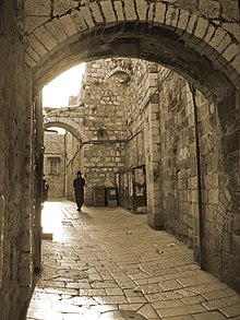
Jerusalem Old City street

Information and Image Obtained From Wikipedia, the free encyclopedia

Anjar

Card no 92
This postcard sent to me by Daniela Rosu Abi Abboud

Anjar, also known as Haoush Mousa is a town of Lebanon located in the Bekaa Valley. The population is about 2,400. Anjar's six neighborhoods are: Haji Hababli, Kabusia, Vakif, Khodr Bek, Yoghun Oluk, Bitias. Anjar also contains a special sector containing the Anjar antiquities and ruins. The majority of Anjar's Armenians are Armenian Apostolics (Orthodox) and belong to the Armenian Apostolic Church and Holy See of Cilicia. Armenian Apostolic Saint Paul Church is the second largest Armenian church in Lebanon. Read more

Information Obtained From Wikipedia, the free encyclopedia

Baalbek

Card no 91
This postcard sent to me by Daniela Rosu Abi Abboud

Baalbek is a town in the Bekaa Valley of Lebanon. It is famous for its exquisitely detailed yet monumentally scaled temple ruins of the Roman period, when Baalbek, then known as Heliopolis. It is Lebanon's greatest Roman treasure, largest and most noble Roman temples ever built and it can be counted among the wonders of the ancient world. The gods worshiped here, the triad of Jupiter, Venus and Bacchus, were grafted onto the indigenous deities of Hadad, Atargatis and a young male god of fertility. Local influences are also seen in the planning and layout of the temples, which vary from the classic Roman design. "Baalbek, with its colossal structures, is one of the finest examples of Imperial Roman architecture at its apogee", UNESCO reported in making Baalbek a World Heritage Site in 1984. When the Committee inscribed the site, it expressed the wish that the protected area include the entire town within the Arab walls, as well as the south-western extramural quarter between Bastan-al-Khan, the Roman site and the Mameluk mosque of Ras-al-Ain. Lebanon's representative gave assurances that the Committee's wish would be honored. Read more

Information Obtained From Wikipedia, the free encyclopedia

Tuesday, September 28, 2010

Saint Basil's Cathedral

Card # 89
Another UNESCO postcard from postcrossing

Saint Basil's Cathedral, is a Russian Orthodox cathedral erected on the Red Square in Moscow in 1555–1561. Built on the order of Ivan IV of Russia to commemorate the capture of Kazan and Astrakhan, it marks the geometric center of the city and the hub of its growth since the 14th century. It was the tallest building of Moscow until the completion of the Ivan the Great Bell Tower in 1600. Read more

Postcard, early 20th century

The cathedral has operated as a division of the State Historical Museum since 1928. It was completely secularized in 1929 and, as of 2009, remains a federal property of the Russian Federation. The cathedral has been part of the Moscow Kremlin and Red Square UNESCO World Heritage Site since 1990.

Information and Image Obtained From Wikipedia, the free encyclopedia

Sunday, September 26, 2010

New Seven Wonders of the World


New Seven Wonders of the World was a project that attempted to update the Seven Wonders of the Ancient World concept with a modern list of wonders. The New7Wonders Foundation, established in 2001, relied on private donations and the sale of broadcast rights and received no public funding or taxpayers' money. After the final announcement, New7Wonders said it didn't earn anything from the exercise and barely recovered its investment. Read more

Taj Mahal,India Agra, India
ताज महल
تاج محل

Chichen Itza, Mexico Yucatán, Mexico
Chi'ch'èen Ìitsha'

Christ the Redeemer, Brazil Rio de Janeiro, Brazil
O Cristo Redentor

Colosseum, Italy Rome, Italy
Colosseo

Great Wall of China, People's Republic of China China
萬里長城
Wànlǐ Chángchéng

Machu Picchu, Peru Cuzco, Perú
Machu Pikchu

Petra, Jordan Jordan
البتراء
al-Batrāʾ

Information Obtained From Wikipedia, the free encyclopedia

LinkWithin

Related Posts with Thumbnails