Total Pageviews

Saturday, September 29, 2012

2012 Summer Olympics-London 2012

Games of the XXX Olympiad

The 2012 Summer Olympics, officially the Games of the XXX Olympiad, and also more generally known as London 2012, was a major international multi-sport event, celebrated in the tradition of the Olympic Games, as governed by the International Olympic Committee (IOC), that took place in London, United Kingdom, from 27 July to 12 August 2012. The first event, the group stages in women's football, began two days earlier, on 25 July. More than 10,000 athletes from 204 National Olympic Committees (NOCs) participated.

Following a bid headed by former Olympic champion Sebastian Coe and then-Mayor of London Ken Livingstone, London was selected as the host city on 6 July 2005 during the 117th IOC Session in Singapore, defeating bids from Moscow, New York City, Madrid and Paris. London was the first city to officially host the modern Olympic Games three times, having previously done so in 1908 and in 1948.

A London 2012 Olympics banner at the Monument in London

Construction in preparation for the Games involved considerable redevelopment, particularly themed towards sustainability. The main focus was a new 200-hectare (490-acre) Olympic Park, constructed on a former industrial site at Stratford, East London. The Games also made use of venues which were already in place before the bid.

Olympic rings marked on a street, indicating that the lane was reserved for the use of Olympic athletes and staff.

The Games received widespread acclaim for their organisation, with the volunteers, the British military, and public enthusiasm praised particularly highly. The opening ceremony, directed by Danny Boyle, also received near-universal acclaim. During the Games, Michael Phelps became the most decorated Olympic athlete of all time, winning his 22nd medal. Great Britain achieved its highest tally of gold medals since 1908, finishing third in the medal table. Saudi Arabia, Qatar and Brunei entered female athletes for the first time, meaning every currently eligible country has sent a female competitor to at least one Olympic Games. With women's boxing included, the Games became the first at which every sport had female competitors.
Read more

Information and Image Obtained From Wikipedia, the free encyclopedia

Hospicio Cabañas, Guadalajara

Card No. 157
Card from Irma Draz Facebook Friend

The Hospicio Cabañas in Guadalajara, Jalisco, Mexico, a World Heritage Site, is one of the oldest and largest hospital complexes in the Americas.

The complex was founded in 1791 by the Bishop of Guadalajara in order to combine the functions of a workhouse, hospital, orphanage, and almshouse. It owes its name to Juan Ruiz de Cabañas who was appointed to the see of Guadalajara in 1796 and engaged Manuel Tolsá, a renowned architect from Mexico City, to design the structure.

Tolsá's design was based on classic examples such as Les Invalides in Paris and El Escorial near Madrid. The buildings form a rectangle measuring 164 m by 145 m. These are single-storey structures which are 7.5 m in height. The chapel is twice as high and has a dome rising to 32.5 m. The complex is erected on one level, "so as to facilitate the movement of the sick, the aged, and children. Following the death of Cabañas in 1823, construction continued until 1829. Although it served for a time as a barracks in the mid-19th century, the hospital lasted well into the 20th century and continued to function until 1980, when the Cabañas Cultural Institute, with affiliated schools for arts and crafts, moved in. The highlight of the interior decoration is a series of monumental frescoes by José Clemente Orozco, including one of his most famed creations, the allegory of The Man of Fire (1936–39).

Information Obtained From Wikipedia, the free encyclopedia

Heritage of Mercury. Almadén and Idrija

Card No. 156

Heritage of Mercury. Almadén and Idrija is a joint UNESCO’s World Heritage site in Almadén, Spain, and Idrija, Slovenia.

The property encompasses two mercury mining sites. In Almadén mercury has been extracted since Antiquity, while in Idrija it was first found in 1490 A.D. The Almadén site includes buildings relating to its mining history, including Retamar Castle, religious buildings and traditional dwellings. The site in Idrija notably features mercury stores and infrastructure, as well as miners’ living quarters, and a miners’ theatre. The sites bear testimony to the intercontinental trade in mercury which generated important exchanges between Europe and America over the centuries. The two sites represent the two largest mercury mines in the world and were operational until recent times.

Information Obtained From Wikipedia, the free encyclopedia

Thursday, September 20, 2012

Agave Landscape and Ancient Industrial Facilities of Tequila

Card No 155
Card from Irma Draz Facebook Friend

The domestication of wild agave seems to have begun around 3,500 years ago. The wild plant may have originated in the Rio Grande canyon. The agave plant is ideally suited to the poor soil and rough terrain of the Tequila area.

Agave was extensively cultivated by the Teuchitlans and served to provide many basis necessities: its fibres were used for fabric, rope and paper, the flower stem provided wood for construction, the fleshy leaves were used as roof tiles and fuel, the spines for needles and arrow heads, the sap produced a type of honey and its juices were used for medicinal balm and fermented to produce an alcoholic drink. The leaders of the complex, stratified, Teuchitlan society created wealth from their apparent monopoly of the agave resources.

To transform the starches in the plant to sugar, for eating and fermenting into alcohol, the pineapples need cooking. There is archaeological evidence from nearby Lake Sayula (outside the nominated area) that the practice of cooking agave pineapples in open, conical ovens, made of volcanic stone, existed around 400 BC. These ovens were preheated with wood and the pineapples covered with branches and clay.

The Spanish priest, Friar Francisco Ximenez, wrote in 1615 how juice from the cooked plant was fermented to make wine flavoured with orange and melon rinds.

In the 16th century the area was conquered by the Spanish who established the town of Santiago de Tequila. The Caxcanes who were living in the areas gradually assimilated with the Spanish. In order to mitigate shortages of spirits from Europe, the Spanish experimented with local beverages and begun to distil the agave fermented juice to make vino de mezcal. At the same time rum was being developed in the Antilles and so the necessary equipment for the new agave spirit was introduced from the rum making areas.

The taxes levied on the new spirit produced a significant income for the Spanish government of Guadalajara. It funded a water supply and the government palace of Jalisco in Guadalajara. Read more

Information Obtained from unesco.org

Luther Memorials in Eisleben and Wittenberg

Card No 154

Card from Katrin Fraenkler Facebook Friend

Eisleben is a town in Saxony-Anhalt, Germany. It is famous as the hometown of Martin Luther, hence its official name is Lutherstadt Eisleben. As of 2005, Eisleben had a population of 24,552. It lies on the Halle–Kassel railway.

Eisleben is divided into old and new towns (Altstadt and Neustadt); the latter of which was created for Eisleben's miners in the 14th century.
Eisleben was first mentioned in 997 as a market called Islebia and in 1180 as a town. It belonged to the counts of Mansfeld until it passed to the Electorate of Saxony in 1780. It was assigned to the Kingdom of Prussia in 1815 and was administered within the Prussian Province of Saxony. It became part of the new state of Saxony-Anhalt after World War II. Read More

Information Obtained From Wikipedia, the free encyclopedia

Saturday, July 28, 2012

Sun Temple, Konark

Card No. 153
Entrance to bhoga-mandapa

Konark Sun Temple is a 13th century Sun Temple (also known as the Black Pagoda), at Konark, in Orissa. It was constructed from oxidized and weathered ferruginous sandstone by King Narasimhadeva I (1238-1250 CE) of the Eastern Ganga Dynasty. Legend has it that the temple was constructed by Samba, the son of Lord Krishna. It is said that Samba was afflicted by leprosy, brought about by his father’s curse on him. After 12 years of penance, he was cured by Surya, the Sun God, in whose honour he built the magnificent Konark Sun Temple. The name Konark is derived from the Sanskrit word Kona (meaning angle) and word Arka (meaning sun) in reference to the temple which was dedicated to the Sun god Surya.

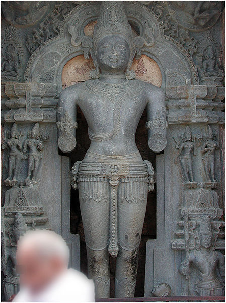
A sculpture of Surya - the Sun God at Konark

Located on the shoreline, now a little over 3 km from the sea, the temple takes the form of the chariot of Surya (Arka), the Sun God, and is heavily decorated with stone carving. The entire complex was designed in the form of the God's huge chariot drawn by seven spirited horses on twelve pairs of exquisitely decorated wheels at its base. The huge wheels carved at the base of the temple are one of the major attractions. The spokes of the wheels serve as sundials and the shadows cast by these can give the precise time of the day. The pyramidal roof soars over 30 m (98 ft) in height. The temple complex also contains erotic sculptures similar to the temple in Khajuraho. Read more
Information and Image Obtained From Wikipedia, the free encyclopedia

Churches and Convents of Goa

Card No. 152
Relic casket of St Francis Xavir, Old Goa (Velha Goa)

The remains of the city are a UNESCO World Heritage Site

Old Goa or Velha Goa (Velha means "old" in Portuguese) is a historical city in North Goa district in the Indian state of Goa. The city was constructed by the Bijapur Sultanate in the 15th century, and served as capital of Portuguese India from the 16th century until its abandonment in the 18th century due to a plague. It is said to have once been a city of nearly 200,000 where from, before the plague, the Portuguese traded across continents. The remains of the city are a UNESCO World Heritage Site. Old Goa is barely 10 kilometers from the state capital of Panaji.

The city was founded in the 15th century as a port on the banks of the Mandovi river by the rulers of the Bijapur Sultanate. The city was built to replace Govapuri, which lay a few kilometres to the south and had been used as a port by the Kadamba and Vijayanagar kings. Old Goa was the second capital of Bijapur under the rule of Adil Shah. It was surrounded by a moat and contained the Shah's palace, and his mosques and temples. The city was captured by the Portuguese, and was under Portuguese rule from 1510 as the administrative seat of Portuguese India. The Viceroy's residence was transferred in 1759 to the future capital, Panaji (then Pangim), at the time a village about 9 kilometres to its west.

During the mid-16th century, the Portuguese colony of Goa, especially Velha Goa, was the center of Christianisation in the East. The city was evangelised by all religious orders, since all of them had their headquarters there.[3] The population was roughly 200,000 by 1543. Malaria and cholera epidemics ravaged the city in the 17th century and it was largely abandoned, only having a remaining population of 1,500 in 1775. It was then that the viceroy moved to Pangim. It continued to be the de jure capital of Gôa until 1843, when the capital was then shifted to Pangim (Ponnjê in Konkani, Nova Goa in Portuguese and Panjim in English). The abandoned city came to be known as "Velha Goa" (in Portuguese, 'Old Goa'), to distinguish it from the new capital Nova Goa (Panjim) and probably also Goa Velha (also meaning "Old Goa"), which was the Portuguese name for the town located on the old site of Govapuri.

Velha Goa was incorporated into the Republic of India in 1961, together with the rest of Goa. Read more

Informatiom was Obtained From Wikipedia, the free encyclopedia

Wednesday, July 18, 2012

Ajanta Caves

Card No. 151
Buddha Mother & Child Ajanta Cave No.1

Since 1983, the Ajanta Caves have been a UNESCO World Heritage Site. The caves are located in the Indian state of Maharashtra, near Jalgaon, just outside the village of Ajinṭhā (20°31′56″N 75°44′44″E). Caves are only about 59 kilometers from Jalgaon Railway station (on Delhi - Mumbai, Rail line of the Central railways, India); and 104 kilometers from Aurangabad (from Ellora Caves 100 Kilometers). Ajanta Caves 30 rock-cut cave monuments which date from the 2nd century BCE to the 600 CE. The caves include paintings and sculptures considered to be masterpieces of Buddhist religious art (which depict the Jataka tales) as well as frescos which are reminiscent of the Sigiriya paintings in Sri Lanka. The caves were built in two phases starting around 2nd century BCE, with the second group of caves built around 600 CE. It is a protected monument under the Archaeological Survey of India. Read more

Information and Image Obtained From Wikipedia, the free encyclopedia

Sunday, July 8, 2012

Tongariro National Park

Card No. 150

The mountain summits are of great significance to the local Māori.

In 1886 in order to prevent the selling of the mountains to European settlers, the local Ngati Tuwharetoa iwi had the mountains surveyed in the Native Land Court and then set aside (whakatapua) as a reserve in the names of certain chiefs one of whom was Te Heuheu Tukino IV (Horonuku), the most significant chief of the Māori Ngati Tuwharetoa iwi. Later the peaks of Mount Tongariro, Mount Ngauruhoe, and parts of Mount Ruapehu, were conveyed to The Crown on 23 September 1887, on condition that a protected area was established there.

This 26.4 km² area was generally considered to be too small to establish a national park after the model of Yellowstone National Park in Wyoming (USA), and so further areas were acquired. When the Parliament of New Zealand passed the Tongariro National Park Act in October 1894, the park covered an area of about 252.13 km², but it took until 1907 to acquire the land. When the Act was renewed in 1922, the park area was extended to 586.8 km². Further extensions, especially Pihanga Scenic Reserve in 1975, enlarged the park to its current size of 795.98 km². The last modification to the Act was passed in 1980. Tongariro National Park has been under the control of the New Zealand Department of Conservation since the creation of the department in 1987.

The first activities in the young Tongariro National Park were the construction of tourist huts at the beginning of the 20th century. But it was not before opening of the railway in 1908 and the building of roads in the 1930s that a significant number of people visited the park. The second Tongariro National Park Act, in 1922, started some active conservation efforts, but it was not until 1931 that the first permanent park ranger began work. Road construction into Whakapapa valley had already begun in the 1920s. The first ski hut was built in 1923 at an elevation of 1770 m, thereafter a road, and, in 1938, a ski lift in the area. This early tourist development explains the rather uncommon existence of a permanently inhabited village and fully developed ski area within a national park. The hotel Chateau Tongariro, which is still the centre of Whakapapa today, was established in 1929.

In the early 20th century, park administrators introduced heather to the park, for grouse hunting. Grouse were never actually introduced, but the heather is sprawling, threatening the ecological system and endemic plants of the park. Efforts are being made to control the plant's spread, however complete eradication seems unlikely. Tongariro National Park is the oldest national park in New Zealand, located in the central North Island. It has been acknowledged by UNESCO as one of the 28 mixed cultural and natural World Heritage Sites.

Tongariro National Park was the fourth national park established in the world. The active volcanic mountains Ruapehu, Ngauruhoe, and Tongariro are located in the centre of the park.

There are a number of Māori religious sites within the park and the summits of Tongariro, including Ngauruhoe and Ruapehu, are tapu (sacred). The park includes many towns around its boundary including Ohakune, Waiouru, Horopito, Pokaka, Erua, National Park Village, Whakapapa skifield and Turangi. Read more

 The three volcanoes: snow-capped Ruapehu (left), conical Ngauruhoe (centre) and broad-domed Tongariro (right)

Information and Image Obtained From Wikipedia, the free encyclopedia

Rock Shelters of Bhimbetka

Card No. 149
Man with dog, Rangmahal Roch-shelter (Group-ll)
The Bhimbetka rock shelters are an archaeological World Heritage site located in Raisen District in the Indian state of Madhya Pradesh. The Bhimbetka shelters exhibit the earliest traces of human life in India and deliver traces of dance from prehistoric times; a number of analyses suggest that at least some of these shelters were inhabited by hominids like homo erectus more than 100,000 years ago. Some of the Stone Age rock paintings found among the Bhimbetka rock shelters are approximately 30,000 years old (Paleolithic Age).

The name Bhimbetka is associated with Bhima, a hero-deity renowned for his immense strength, from the epic Mahabharata. The word Bhimbetka is said to derive from Bhimbaithka, meaning "sitting place of Bhima".

Bhimbetka Caves, Madhya Pradesh

As reported in the UNESCO citation declaring the Rock Shelters of Bhimbetka as a World Heritage Site, Bhimbetka was first mentioned in Indian archeological records in 1888 as a Buddhist site, based on information gathered from local adivasis. Later, as V. S. Wakankar was traveling by train to Bhopal he saw some rock formations similar to those he had seen in Spain and France. He visited the area along with a team of archaeologists and discovered several prehistoric rock shelters in 1957.

Since then more than 700 such shelters have been identified, of which 243 are in the Bhimbetka group and 178 in the Lakha Juar group. Archeological studies revealed a continuous sequence of Stone Age cultures (from the late Acheulian to the late Mesolithic), as well as the world’s oldest stone walls and floors. There have been found also the oldest known petroglyphs of the world in 1990 - 1991 - 10 cupules and meandering line which could be up to 150,000 years old. The earliest paintings on the cave walls are believed to be of the Mesolithic period. A broad chronology of the finds has been done, but a detailed chronology is yet to be created.

The caves have evolved over time into excellent rock-shelters, ideal sites for aboriginal settlements. The smooth shape of the rocks has led some scientists to believe that the area was once under water. The rocks have taken on incredible shapes in several stunning hues and textures. Apart from the central place the aboriginal drawings have in human history, the caves themselves offer interesting material for a study of the Earth's history.

Barkheda has been identified as the source of the raw materials used in some of the monoliths discovered at Bhimbetka. Read more

Information and Image Obtained From Wikipedia, the free encyclopedia

Sunday, July 1, 2012

Classical Gardens of Suzhou

Card No. 148
The Classical Gardens of Suzhou are a group of gardens in Suzhou region, Jiangsu province which have been added to the UNESCO World Heritage List.

Spanning a period of almost one thousand years, from the Northern Song to the late Qing dynasties (11th-19th century), these gardens, most of them built by scholars, standardized many of the key features of classical Chinese garden design with constructed landscapes mimicking natural scenery of rocks, hills and rivers with strategically located pavilions and pagodas.

Though smaller and less elaborate than another well-known types of Chinese garden, the opulent Imperial Gardens and Palaces in Beijing, best exemplified by the Beihai Park, Zhongshan Park, Old Summer Palace and Summer Palace; the elegant aesthetics and subtlety of these scholar's gardens in many ways contrast with the grandeur of the former, and their delicate style and features are often imitated by various gardens in other parts of China, including the Imperial Gardens, such as those in the Chengde Mountain Resort. According to UNESCO, the gardens of Suzhou "represent the development of Chinese landscape garden design over more than two thousand years," and they are the "most refined form" of garden art.

These landscape gardens flourished in the mid-Ming to early-Qing dynasties, resulting in as much as 200 private gardens. Today, there are 69 preserved gardens in Suzhou, and all of them are designated as protected "National Heritage Sites." In 1997 and 2000, eight of the finest gardens in Suzhou along with one in the nearby ancient town of Tongli were selected by UNESCO as a World Heritage Site to represent the art of Suzhou-style classical gardens

Information Obtained From Wikipedia, the free encyclopedia


View of Couple's Retreat Garden
Hanshan Temple
Humble Administrator's Garden
Lingering Garden
Lion Forest Garden
Master-of-Nets Garden
The Mountain villa with Embracing Beauty
The Canglang Pavilion
The Retreat and Reflection Garden
Tiger Hill

Sunday, June 24, 2012

Jewish Quarter and St. Procopius' Basilica in Trebíc

Card No. 147

Třebíč is a city in the Moravian part of the Vysočina Region of the Czech Republic.
Třebíč is situated 35 km southeast of Jihlava and 65 km west of Brno on the Jihlava River. Třebíč is from 392 to 503 metres above sea-level. Třebíč has a temperate climate with occasional rains. Average annual temperature is 7.5°C, average temperature in July is 18.5°C and -3.4°C in January.

Třebíč is a regional centre with a population of approximately 40,000. In the age of expansion Třebíč was third most important town in Moravia. The population growth started after World War II. Třebíč is an important regional center today. There are many sights. The Jewish Quarter and St Procopius' Basilica is listed as a UNESCO World Heritage Site. Read more
Information Obtained From Wikipedia, the free encyclopedia

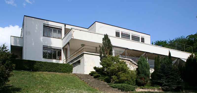
Tugendhat Villa in Brno

Card No. 146
In 1993 the Villa Tugendhat Fund and Friends of Tugendhat were formed to preserve the house. In 1995 Brno received a $15,000 grant to pay for preliminary research from the Samuel H. Kress European Preservation Program, part of the World Monuments Fund. Then the International Music and Art Foundation, based in Lichtenstein, got involved, pledging $100,000, because a trustee, Nicholas Thaw, was also a trustee of the World Monuments Fund. The Robert Wilson Foundation matched the $100,000. Villa Tugendhat was designated a World Heritage Site by UNESCO in 2001. Read more


Holy Trinity Column in Olomouc

Card No. 145

Olomouc contains several large squares, the chief of which is adorned with the Holy Trinity Column, a UNESCO World Heritage Site. The column is 115 ft (35 m) high and was built between 1716 and 1754. Olomouc is said to occupy the site of a Roman fort founded in the imperial period, the original name of which, Iuliomontium (Mount Julius), would have been gradually corrupted to the present form. Read more

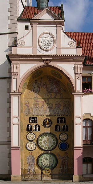
Olomouc astronomical clock
Information and Image Obtained From Wikipedia, the free encyclopedia

Litomyšl Castle

Card No. 144

The eastern Bohemian town of Litomyšl emerged in the 13th century on the site of an older fortified settlement on the Trstenice path - an important trading route linking Bohemia and Moravia. Litomyšl is a town and municipality in the Pardubice Region of the Czech Republic. The chateau complex in the town centre is listed as a UNESCO World Heritage Site.
Read more

Information and Image Obtained From Wikipedia, the free encyclopedia

Gardens and Castle at Kroměříž

Card 143

Kroměříž stands on the site of an earlier ford across the River Morava, at the foot of the Chriby mountain range which dominates the central part of Moravia. The gardens and castle of Kroměříž are an exceptionally complete and well-preserved example of a European Baroque princely residence and its gardens.

The Gardens and Castle at Kroměříž are an exceptionally complete and well-preserved example of a princely residence and its associated landscape of the 17th and 18th centuries. The ensemble, and in particular the pleasure garden, played a significant role in the development of Baroque garden and palace design in central Europe

Kroměříž did not achieve the status of a fortified until the mid-13th century, when a Gothic fort was constructed, and the town prospered in the succeeding centuries. In 1497 Stanislav Thurzo became Bishop of Olomouc and he set about reconstructing and modernizing his castle at Kroměříž. At first this work was carried out using the late Gothic style of the period, but Renaissance elements began to filter in as the work progressed. Bishop Thurzo also established a garden, comprising orchard, kitchen garden and flower garden, which was praised by King Vladislav II when he visited Kroměříž in 1509.

The castle suffered grievously in the Thirty Years' War when the town was sacked by the Swedish army in 1643, a disaster that was followed by an outbreak of plague two years later. When Count Karel Liechtenstein-Castelcorn became Bishop of Olomouc in 1664, the town's fortunes began to change. He undertook many building projects and brought in the talented imperial civil engineer and architect Filiberto Lucchese, who designed an entirely new pleasure garden (Lustgarten ) for him after having brought the ruined castle back into a habitable state. When Lucchese died in 1666, his work was taken over by Giovanni Pietro Tencalla; the work on the garden was not completed until 1675. Once it was finished Tencalla's attention turned to the design and construction of a magnificent Episcopal castle and residence.

The castle was affected by the fire that swept through the town in March 1752. Bishop Leopold Bedrich Eglik oversaw the restoration, bringing in artists and craftsmen to carry out the work. The first archbishop, Colloredo-Waldsee, was responsible for the restyling of the castle garden in accordance with the Romantic approach of the late 18th century; the pleasure garden, however, preserved its Baroque geometrical layout. The work on the castle garden continued well into the 19th century, with the construction of arcades, bridges and even a model farmstead. Much of this work was carried out under the supervision of the architect Antonín Arche between 1830 and 1845.

The main building of the castle is a free-standing structure with four wings round a trapezoidal central courtyard and rising to three storeys, with an attic half-storey above. The ground floor is set on a high platform, built to compensate for the uneven nature of the ground. It was originally surrounded by a moat, filled in 1832. In the interior, the first floor is, according to custom, the piano nobile, where the main rooms were located - Throne Room, Conference Hall and two dining rooms; the second floor houses the guest rooms, the Library, the Vassal or Feudal Hall and the Chapel. On the garden front of the castle there is a small Baroque terrace garden, the giardino segreto , which is approached by an arcaded corridor with a double staircase, known as the Colloredo Colonnade and built in 1795.

The castle is linked to the castle garden through spacious ground-floor rooms with grottoes opening out of them, one of them reproducing a mine. Within the garden there are several important architectural features. A semi-circular colonnade in classical style was built in 1846 to house sculptures from Pompeii. On the western periphery Max's Farmstead is a luxurious building in French Empire style, with an impressive colonnade and projecting wings. Cast iron, produced at the archiepiscopal foundry, was used for the elegant Little Silver, Vase and Little Lantern bridges. The pleasure garden, in the south-western part of the historic centre of Kroměříž, is a formal garden in the Italian style, entered by an arcaded gallery which contains many statues and busts.
Source: UNESCO/CLT/WHC
Historical Description

The history of Kromeríz began with the establishment of a settlement in the floodplain of the Morava river in the 9th century AD during the Greater Moravian Period. By the 12th century, when it belonged to the Bishopric of Olomouc, the original fortified site had disappeared. It did not achieve the status of a fortified town again until the mid-13th century, when a Gothic fort was constructed. The town prospered in the succeeding centuries, becoming the centre of the organization of vassals of the episcopal domains.

In 1497 the wealthy and well-connected Stanislav Thurzo became Bishop of Olomouc. He set about reconstructing and modernizing his castle at Kromeríz. At first this work was carried out using the Late Gothic style of the period, but Renaissance elements began to filter in as the work progressed. Bishop Thurzo also established a garden, comprising orchard, kitchen garden, and flower garden, which was praised by King Vladislav II when he visited Kromeríz in 1509.

Thurzo's successors made minor modifications and additions to his castle. The castle suffered grievously in the Thirty Years' War when the town was sacked by the Swedish army in 1643, a disaster followed by an outbreak of plague two years later. It was not until Count Karel Liechtenstein-Castelcorn became Bishop of Olomouc in 1664 that the town's fortunes began to change. He wanted the town where he lived to have an aristocratic air, and so he undertook many building projects, as well as compelling the burghers to renew their buildings and equipment.

He brought in the talented Imperial civil engineer and architect Filiberto Lucchese, who designed an entirely new Pleasure Garden (Lustgarten) for him after having brought the ruined castle back into a habitable state. When Lucchese died in 1666, his work was taken over by his successor as Imperial architect, Giovanni Pietro Tencalla; the work on the Garden was not completed until 1675.

Once the garden was finished Tencalla's attention turned to the design and construction of a magnificent episcopal castle and residence. This was to be his masterpiece, in the tradition of the north Italian Baroque school of Genoa and Turin. Nonetheless, it respected its Gothic predecessor, elements of which were blended into the new complex. Meanwhile, Bishop Karel was furnishing the interiors, creating a picture gallery that contained many masterpieces.

The castle was affected by the fire that swept through the town in March 1752. Bishop Leopold Bedrich Eghk oversaw the restoration, bringing in artists and craftsmen to carry out the work, notably the Viennese painter Franz Anton Maulbertsch and the Moravian artists Josef Stern.


The see was raised to an archbishopric in 1777 and the first archbishop, Colloredo-Waldsee, was responsible for the restyling of the Castle Garden in accordance with the romantic approach of the late 18th century. The Pleasure Garden, however, preserved its Baroque geometrical layout. The work on the Castle Garden continued well into the 19th century, with the construction of arcades, bridges, and even a model farmstead. Much of this was carried out under the supervision of the architect Antonín Arche between 1830 and 1845.

Information Obtained from http://whc.unesco.org

Holašovice Historical Village Reservation

Card No. 142

Holašovice is a small historic village located in the south of the Czech Republic, 15 kilometres west of České Budějovice. Village belongs to the municipality Jankov. To the south lies the protected landscape area of Blanský Forest. The village was deserted after the Second World War, allowing its medieval plan and vernacular buildings in the South Bohemian Folk or Rural Baroque style to remain intact. It was restored and repopulated from 1990, and it was designated as a UNESCO World Heritage Site in 1998.
Holašovice is first mentioned in 1263. In 1292, King Wenceslaus II gave the village and several others to the Cistercian monastery of Vyšší Brod. It remained the property of the monastery until 1848. Between 1520 and 1525, Holašovice was nearly wiped out by the bubonic plague. Only two of its inhabitants survived. Read more


Information and Image Obtained From Wikipedia, the free encyclopedia

Monday, May 14, 2012

Lednice-Valtice Cultural Landscape

Card No. 141

The Lednice-Valtice Cultural Landscape (also Lednice-Valtice Area or Lednice-Valtice Complex, Czech: Lednicko-valtický areál) is a cultural-natural complex of 283,09 km² in the Czech Republic, South Moravian Region, close to Břeclav and Mikulov. The Lednice-Valtice Area is registered in the list of monuments protected as World Heritage by UNESCO next to another site - Pálava Landscape Protected Area, registered by UNESCO only a few years prior to the nearby Pálava Biosphere Reserve. Such close proximity of two landscape systems protected by UNESCO is world-unique. Readmore

Information Obtained From Wikipedia, the free encyclopedia

Kutná Hora: Historical Town Centre with the Church of St Barbara and the Cathedral of Our Lady at Sedlec

Card No. 140

The town began in 1142 with the settlement of the first Cistercian monastery in Bohemia, Sedlec Monastery, brought from the Imperial immediate Cistercian Waldsassen Abbey. By 1260 German miners began to mine for silver in the mountain region, which they named Kuttenberg, and which was part of the monastery property. The name of the mountain is said to have derived from the monks' cowls or from the word mining (kutání in old Czech). Under Abbot Heinrich Heidenreich the territory greatly advanced due to the silver mines which gained importance during the economic boom of the 13th century.

The earliest traces of silver have been found dating back to the 10th century, when Bohemia already had been in the crossroads of long-distance trade for many centuries. Silver dinars have been discovered belonging to the period between 982-995 in the settlement of Malín, which is now a part of Kutná Hora.

From the 13th to 16th centuries the city competed with Prague economically, culturally and politically.[1] Since 1995 the city center has been a UNESCO World Heritage Site. Readmore

Information Obtained From Wikipedia, the free encyclopedia

Pilgrimage Church of St John of Nepomuk at Zelená Hora

Card No. 139

The Pilgrimage Church of St John Nepomuk at Želena Hora, Ždár nad Sázavou, is a masterpiece of an architectural style that spanned the transition between the Gothic and Baroque traditions. Readmore

Historic Centre of Telc

Card No. 138

The houses in Telc, which stands on a hilltop, were originally built of wood. After a fire in the late 14th century, the town was rebuilt in stone, surrounded by walls and further strengthened by a network of artificial ponds. The town's Gothic castle was reconstructed in High Gothic style in the late 15th century.Telč is also an architectural and artistic ensemble of outstanding quality. The quality of the architecture is high, particularly the Renaissance market place and chateau. Its triangular market place possesses great beauty and harmony as well as great cultural importance, surrounded as it is by intact and well-preserved Renaissance buildings with a dazzling variety of facades. Read more

Information Obtained from whc.unesco.org

Historic Centre of Český Krumlov

Card No. 137

Situated on the banks of the Vltava river, the town was built around a 13th-century castle with Gothic, Renaissance and Baroque elements. It is an outstanding example of a small central European medieval town whose architectural heritage has remained intact thanks to its peaceful evolution over more than five centuries. The site is located on an ancient east-west communication route at a crossing of the Vltava River. The earliest documentary record of 1253 refers to the existence there of a castle belonging to a member of the ruling Vitkovici family of south Bohemia. There are two main historic areas - the Latrán area below the castle and the town proper on the opposite bank, in the meander of the Vltava River. The town has a regular street layout, typical of the planned towns of the Middle Ages, with streets radiating out from the central square and a circular intra-rampart road. The castle contains elements from the Gothic, High Gothic, Renaissance and Baroque styles. It is dominated by the Gothic Hradek with its round tower; this was subsequently converted into a Baroque chateau with the addition of a garden, the Bellaire summer palace, a winter riding school, and a unique Baroque theatre of 1766. Both Latrán and the town proper contain undisturbed ensembles of burgher houses from High Gothic onwards. They are notable for their facades, internal layouts and decorative detail, especially carved wooden Renaissance ceilings. Readmore

Information Obtained from whc.unesco.org

Historic Centre of Prague

Card No. 136

Built between the 11th and 18th centuries, the Old Town, the Lesser Town and the New Town speak of the great architectural and cultural influence enjoyed by this city since the Middle Ages. The many magnificent monuments, such as Hradcani Castle, St Vitus Cathedral, Charles Bridge and numerous churches and palaces, built mostly in the 14th century under the Holy Roman Emperor, Charles IV.
Prague belongs to the group of historic cities which have preserved the structure of their development until the present times. Within the core of Prague, successive stages of growth and changes have respected the original grand-scale urban structure of the Early Middle Ages.
In the course of the 1100 years of its existence, Prague’s development can be documented in the architectural expression of many historical periods and their styles. The city is rich in outstanding monuments from all periods of its history. Of particular importance are Prague Castle, the Cathedral of St Vitus, Hradćany Square in front of the Castle, the Valdgtejn Palace on the left bank of the river, the Gothic Charles Bridge, the Romanesque Rotunda of the Holy Rood, the Gothic arcaded houses round the Old Town Square, the High Gothic Minorite Church of St James in the Stark Mĕsto, the late 19th century buildings and town plan of the Nave Mĕsto.Readmore
Information Obtained from whc.unesco.org

UNESCO Czech Heritage {1-12}


Sunday, May 13, 2012

Cologne Cathedral

Card No. 135

Another UNESCO Postcard from Postcrossing

Cologne Cathedral is a Roman Catholic church in Cologne, Germany. It is the seat of the Archbishop of Cologne and the administration of the Archdiocese of Cologne. It is a renowned monument of German Catholicism and Gothic architecture and is a World Heritage Site. Cologne Cathedral was commenced in 1248 and left unfinished in 1473. Work recommenced in the 19th century and was completed, to the original plan, in 1880. It is 144.5 metres (474 ft) long, 86.5 m (284 ft) wide and its towers are approximately 157 m (515 ft) tall. The cathedral is the largest Gothic church in Northern Europe and has the second-tallest spires and largest façade of any church in the world. Cologne's medieval builders had planned a grand structure to house the reliquary of the Three Kings and fit its role as a place of worship for the Holy Roman Emperor. Readmore

Information Obtained From Wikipedia, the free encyclopedia

Schokland and Surroundings

Card No. 134

Schokland is a former island in the Dutch Zuiderzee. Schokland lost its status as an island when the Noordoostpolder was reclaimed from the sea in 1942. The remains are still visible as a slightly elevated part in the polder and by the still partly intact retaining wall of the waterfront of 'Middelbuurt'.

As a result from the increasing sea-level Schokland transformed from an attractive settlement area in the Middle Ages to a place under continuous threat by floods in the 19th century. By that time the Schoklanders had retreated to the three most elevated parts, Emmeloord, Molenbuurt, and Middelbuurt. A major flood in 1825 brought massive destruction, and in 1859 the government decided to end permanent settlement on Schokland. The former municipality of Schokland was joined to Kampen on the mainland.

Today Schokland is a popular archeological site and host to the Schokland Museum. Schokland was the first UNESCO World Heritage Site in the Netherlands.


Information Obtained From Wikipedia, the free encyclopedia

Sunday, April 8, 2012

Historic city of Bagan, Myanmar

From FB Friend, Card No. 1
By my FB friend Vincent Legrudge

Los Glaciares National Park

Card No. 133
Another UNESCO Postcard from Postcrossing

The national park, created in 1937, is the second largest in Argentina. Its name refers to the giant ice cap in the Andes range that feeds 47 large glaciers, of which only 13 flow towards the Atlantic Ocean. The ice cap is the largest outside of Antarctica and Greenland. In other parts of the world, glaciers start at a height of at least 2,500 meters above mean sea level, but due to the size of the ice cap, these glaciers begin at only 1,500m, sliding down to 200m AMSL, eroding the surface of the mountains that support them. At the Santa Cruz Province, in Argentine Patagonia. It comprises an area of 4459 km². In 1981 it was declared a World Heritage Site by UNESCO. Read more

Information Obtained From Wikipedia, the free encyclopedia

Sunday, March 25, 2012

Swiss Alps Jungfrau-Aletsch

Card No. 132
Another UNESCO Postcard from Postcrossing

The extension of the natural World Heritage property of Jungfrau - Aletsch - Bietschhorn (first inscribed in 2001), expands the site to the east and west, bringing its surface area up to 82,400 ha., up from 53,900. The site provides an outstanding example of the formation of the High Alps, including the most glaciated part of the mountain range and the largest glacier in Eurasia. It features a wide diversity of ecosystems, including successional stages due particularly to the retreat of glaciers resulting from climate change. The site is of outstanding universal value both for its beauty and for the wealth of information it contains about the formation of mountains and glaciers, as well as ongoing climate change. It is also invaluable in terms of the ecological and biological processes it illustrates, notably through plan succession. Its impressive landscape has played an important role in European art, literature, mountaineering and alpine tourism. Read more

Information Obtained From whc.unesco.org

Droogmakerij de Beemster (Beemster Polder)

Card No. 131
This Postcard sent to me by Mike

Also, the Beemster is the first so-called polder in the Netherlands that was reclaimed from a lake, the water being extracted out of the lake by windmills. The Beemster Polder was dried during the period 1609 through 1612. It has preserved intact its well-ordered landscape of fields, roads, canals, dykes and settlements, laid out in accordance with classical and Renaissance planning principles. A grid of canals parallels the grid of roads in the Beemster. The grids are offset: the larger feeder canals are offset by approximately one kilometer from the larger roads. Read more

Information and Image Obtained From Wikipedia, the free encyclopedia

LinkWithin

Related Posts with Thumbnails